Sebeta geodata
Sebeta (Oromiya) is a populated place; located in Ethiopia in Africa/Addis_Ababa (GMT+3) time zone. With population of 19,533 people, there are 67 cities with bigger population in this country. Compared to other cities in Ethiopia, 50.5% of cities are located further ↑North; 57% of cities are located further ←West and 72% of cities have lower elevation than Sebeta. Note1


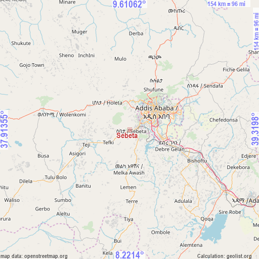
Sebeta GPS coordinates[2]
8° 55' 0.012" North, 38° 37' 0.012" East
| Map corner | latitude | longitude |
|---|---|---|
| Upper-left | 9.61062°, | 37.91355° |
| Center: | 8.91667°, | 38.61667° |
| Lower-right: | 8.2214°, | 39.3198° |
| Map W x H: | 154.5×154.5 km | = 96×96mi |
| max Lat: | 14.277° ⇑50.5% North |
| Sebeta: | 8.91667° |
| min Lat: | ⇓49.5% South 4.05° |
| min Long | Sebeta | max Long |
| 34.53333° | 38.61667° | 42.8° |
| W 57%⇐ | ⇒43% E |
Elevation
Elevation of Sebeta is 2311 m = 7582 ft, and this is 415.4 m = 1363 ft above average elevation for this country.
| Max E: |
2854 m = 9364 ft | 28% |
| Sebeta | 2311 m 7582 ft | |
| Avg. | 1895.6 m = 6219 ft | |
Min E: |
367 m = 1204 ft | 72% |
See also: Ethiopia elevation on elevation.city.
Geographical zone
Sebeta is located in North Torrid zone (between Equator and Tropic of Cancer). Distance of Equator is 991.4 km =616 mi to South.| Distance of | km | miles | from Sebeta |
|---|---|---|---|
| North Pole | 9015.6 | 5602 | to North |
| Arctic Circle | 6409.7 | 3982.8 | to North |
| Tropic Cancer | 1614.5 | 1003.2 | to North |
| Equator | 991.4 | 616 | to South |


Nearby cities:
15 places around Sebeta: (largest is in red/bold)
• Addis Ababa
18.7 km =11.6 mi,  49°
49°
• Bishoftu
43.8 km =27.2 mi,  114°
114°
• Butajīra
93.1 km =57.8 mi,  197°
197°
• Fichē
99 km =61.5 mi,  7°
7°
• Gebre Guracha
101.1 km =62.8 mi,  346°
346°
• Genet
21 km =13 mi,  322°
322°
• Hāgere Hiywet
84.5 km =52.5 mi,  275°
275°
• Mojo
66.5 km =41.3 mi,  123°
123°
• Nazrēt
82.3 km =51.1 mi, 119°
• Sendafa
51.8 km =32.2 mi,  59°
59°
• Tulu Bolo
52 km =32.3 mi,  237°
237°
• Waliso
83.3 km =51.8 mi, 239°
• Wenjī
89.8 km =55.8 mi,  125°
125°
• Ziway
109.9 km =68.3 mi,  174°
174°
• Ādīs ‘Alem
27.1 km =16.8 mi,  298°
298°
Sources, notices
• [Note1] Compared only with cities in Ethiopia existing in our database
• [Src1] Map data: © OpenStreetMap contributors (CC-BY-SA)
• [Src2] Other city data from geonames.org with taken over terms of usage.
• [Src3] Geographical zone / Annual Mean Temperature by Robert A. Rohde @ Wikipedia
