Fichē geodata
Fichē (Oromiya) is a populated place; located in Ethiopia in Africa/Addis_Ababa (GMT+3) time zone. With population of 25,758 people, there are 48 cities with bigger population in this country. Compared to other cities in Ethiopia, 66.4% of cities are located further ↓South; 59.8% of cities are located further ←West and 98.1% of cities have lower elevation than Fichē. Note1


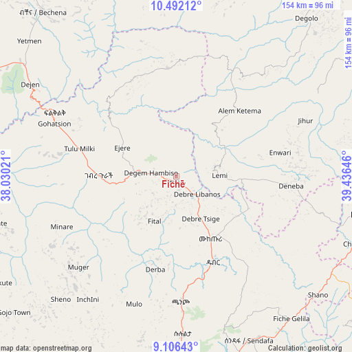
Fichē GPS coordinates[2]
9° 48' 0" North, 38° 43' 59.988" East
| Map corner | latitude | longitude |
|---|---|---|
| Upper-left | 10.49212°, | 38.03021° |
| Center: | 9.8°, | 38.73333° |
| Lower-right: | 9.10643°, | 39.43646° |
| Map W x H: | 154.1×154.1 km | = 95.8×95.8mi |
| max Lat: | 14.277° ⇑33.6% North |
| Fichē: | 9.8° |
| min Lat: | ⇓66.4% South 4.05° |
| min Long | Fichē | max Long |
| 34.53333° | 38.73333° | 42.8° |
| W 59.8%⇐ | ⇒40.2% E |
Elevation
Elevation of Fichē is 2792 m = 9160 ft, and this is 896.4 m = 2941 ft above average elevation for this country.
| Max E: |
2854 m = 9364 ft | 1.9% |
| Fichē | 2792 m 9160 ft | |
| Avg. | 1895.6 m = 6219 ft | |
Min E: |
367 m = 1204 ft | 98.1% |
See also: Ethiopia elevation on elevation.city.
Geographical zone
Fichē is located in North Torrid zone (between Equator and Tropic of Cancer). Distance of Equator is 1089.7 km =677.1 mi to South.| Distance of | km | miles | from Fichē |
|---|---|---|---|
| North Pole | 8917.4 | 5541 | to North |
| Arctic Circle | 6311.5 | 3921.8 | to North |
| Tropic Cancer | 1516.3 | 942.2 | to North |
| Equator | 1089.7 | 677.1 | to South |


Nearby cities:
15 places around Fichē: (largest is in red/bold)
• Addis Ababa
86.2 km =53.6 mi,  179°
179°
• Bichena
92.9 km =57.7 mi,  321°
321°
• Bishoftu
119.6 km =74.3 mi,  166°
166°
• Debre Birhan
88.6 km =55.1 mi,  98°
98°
• Debre Mark’os
125.4 km =77.9 mi,  299°
299°
• Debre Sīna
112.6 km =70 mi,  87°
87°
• Debre Werk’
114.6 km =71.2 mi,  327°
327°
• Dejen
77.3 km =48 mi, 301°
• Gebre Guracha
36.5 km =22.7 mi,  270°
270°
• Genet
85.5 km =53.1 mi,  197°
197°
• Hāgere Hiywet
132.8 km =82.5 mi,  226°
226°
• Sebeta
99 km =61.5 mi,  187°
187°
• Sendafa
78.8 km =49 mi,  156°
156°
• Were Īlu
116.8 km =72.6 mi,  41°
41°
• Ādīs ‘Alem
92.8 km =57.7 mi, 203°
Sources, notices
• [Note1] Compared only with cities in Ethiopia existing in our database
• [Src1] Map data: © OpenStreetMap contributors (CC-BY-SA)
• [Src2] Other city data from geonames.org with taken over terms of usage.
• [Src3] Geographical zone / Annual Mean Temperature by Robert A. Rohde @ Wikipedia
