Ādīs ‘Alem geodata
Ādīs ‘Alem (Oromiya) is a populated place; located in Ethiopia in Africa/Addis_Ababa (GMT+3) time zone. With population of 9,859 people, there are 94 cities with bigger population in this country. Compared to other cities in Ethiopia, 54.2% of cities are located further ↓South; 51.4% of cities are located further →East and 72.9% of cities have lower elevation than Ādīs ‘Alem. Note1


Ādīs ‘Alem GPS coordinates[2]
9° 1' 59.988" North, 38° 24' 0" East
| Map corner | latitude | longitude |
|---|---|---|
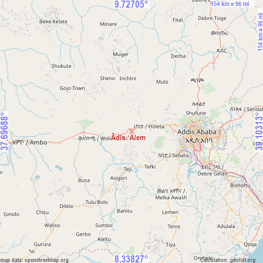
| Upper-left | 9.72705°, | 37.69688° |
| Center: | 9.03333°, | 38.4° |
| Lower-right: | 8.33827°, | 39.10313° |
| Map W x H: | 154.4×154.4 km | = 95.9×95.9mi |
| max Lat: | 14.277° ⇑45.8% North |
| Ādīs ‘Alem: | 9.03333° |
| min Lat: | ⇓54.2% South 4.05° |
| min Long | Ādīs ‘Alem | max Long |
| 34.53333° | 38.4° | 42.8° |
| W 48.6%⇐ | ⇒51.4% E |
Elevation
Elevation of Ādīs ‘Alem is 2315 m = 7595 ft, and this is 419.4 m = 1376 ft above average elevation for this country.
| Max E: |
2854 m = 9364 ft | 27.1% |
| Ādīs ‘Alem | 2315 m 7595 ft | |
| Avg. | 1895.6 m = 6219 ft | |
Min E: |
367 m = 1204 ft | 72.9% |
See also: Ethiopia elevation on elevation.city.
Geographical zone
Ādīs ‘Alem is located in North Torrid zone (between Equator and Tropic of Cancer). Distance of Equator is 1004.4 km =624.1 mi to South.| Distance of | km | miles | from Ādīs ‘Alem |
|---|---|---|---|
| North Pole | 9002.6 | 5594 | to North |
| Arctic Circle | 6396.8 | 3974.8 | to North |
| Tropic Cancer | 1601.5 | 995.1 | to North |
| Equator | 1004.4 | 624.1 | to South |


Nearby cities:
15 places around Ādīs ‘Alem: (largest is in red/bold)
• Addis Ababa
38.1 km =23.7 mi,  91°
91°
• Bishoftu
70.8 km =44 mi,  116°
116°
• Butajīra
102 km =63.4 mi,  182°
182°
• Fichē
92.8 km =57.7 mi,  23°
23°
• Gebre Guracha
85.2 km =52.9 mi,  0°
0°
• Genet
11.6 km =7.2 mi,  71°
71°
• Gēdo
104.3 km =64.8 mi,  268°
268°
• Hāgere Hiywet
60.7 km =37.7 mi,  264°
264°
• Mojo
93.5 km =58.1 mi, 122°
• Nazrēt
109.3 km =67.9 mi, 119°
• Sebeta
27.1 km =16.8 mi, 118°
• Sendafa
69.7 km =43.3 mi,  79°
79°
• Tulu Bolo
45.5 km =28.3 mi,  206°
206°
• Waliso
73.2 km =45.5 mi,  220°
220°
• Wenjī
116.7 km =72.5 mi, 123°
Sources, notices
• [Note1] Compared only with cities in Ethiopia existing in our database
• [Src1] Map data: © OpenStreetMap contributors (CC-BY-SA)
• [Src2] Other city data from geonames.org with taken over terms of usage.
• [Src3] Geographical zone / Annual Mean Temperature by Robert A. Rohde @ Wikipedia
