Bishoftu geodata
Bishoftu (Oromiya) is a populated place; located in Ethiopia in Africa/Addis_Ababa (GMT+3) time zone. With population of 104,215 people, there are 9 cities with bigger population in this country. Compared to other cities in Ethiopia, 54.2% of cities are located further ↑North; 63.6% of cities are located further ←West and 55.1% of cities have lower elevation than Bishoftu. Note1


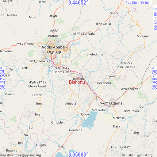
Bishoftu GPS coordinates[2]
8° 45' 8.1" North, 38° 58' 42.456" East
| Map corner | latitude | longitude |
|---|---|---|
| Upper-left | 9.44652°, | 38.27534° |
| Center: | 8.75225°, | 38.97846° |
| Lower-right: | 8.05668°, | 39.68159° |
| Map W x H: | 154.5×154.5 km | = 96×96mi |
| max Lat: | 14.277° ⇑54.2% North |
| Bishoftu: | 8.75225° |
| min Lat: | ⇓45.8% South 4.05° |
| min Long | Bishoftu | max Long |
| 34.53333° | 38.97846° | 42.8° |
| W 63.6%⇐ | ⇒36.4% E |
Elevation
Elevation of Bishoftu is 1978 m = 6490 ft, and this is 82.4 m = 270 ft above average elevation for this country.
| Max E: |
2854 m = 9364 ft | 44.9% |
| Bishoftu | 1978 m 6490 ft | |
| Avg. | 1895.6 m = 6219 ft | |
Min E: |
367 m = 1204 ft | 55.1% |
See also: Bishoftu elevation on elevation.city.
Geographical zone
Bishoftu is located in North Torrid zone (between Equator and Tropic of Cancer). Distance of Equator is 973.2 km =604.7 mi to South.| Distance of | km | miles | from Bishoftu |
|---|---|---|---|
| North Pole | 9033.9 | 5613.4 | to North |
| Arctic Circle | 6428 | 3994.2 | to North |
| Tropic Cancer | 1632.8 | 1014.6 | to North |
| Equator | 973.2 | 604.7 | to South |


Nearby cities:
15 places around Bishoftu: (largest is in red/bold)
• Addis Ababa
39.6 km =24.6 mi,  320°
320°
• Butajīra
97.6 km =60.6 mi,  223°
223°
• Genet
63.1 km =39.2 mi,  303°
303°
• Huruta
78.4 km =48.7 mi,  148°
148°
• Metahāra
104.4 km =64.9 mi,  80°
80°
• Mojo
24.2 km =15 mi,  139°
139°
• Nazrēt
38.9 km =24.2 mi,  125°
125°
• Sebeta
43.8 km =27.2 mi,  294°
294°
• Sendafa
44.7 km =27.8 mi,  6°
6°
• Sirre
73.7 km =45.8 mi, 131°
• Tulu Bolo
84.3 km =52.4 mi,  263°
263°
• Waliso
114 km =70.8 mi, 257°
• Wenjī
47.5 km =29.5 mi, 135°
• Ziway
95.5 km =59.3 mi,  197°
197°
• Ādīs ‘Alem
70.8 km =44 mi, 296°
Sources, notices
• [Note1] Compared only with cities in Ethiopia existing in our database
• [Src1] Map data: © OpenStreetMap contributors (CC-BY-SA)
• [Src2] Other city data from geonames.org with taken over terms of usage.
• [Src3] Geographical zone / Annual Mean Temperature by Robert A. Rohde @ Wikipedia
