Wenjī geodata
Wenjī (Oromiya) is a populated place; located in Ethiopia in Africa/Addis_Ababa (GMT+3) time zone. With population of 17,120 people, there are 73 cities with bigger population in this country. Compared to other cities in Ethiopia, 60.7% of cities are located further ↑North; 71% of cities are located further ←West and 81.3% of cities have higher elevation than Wenjī. Note1


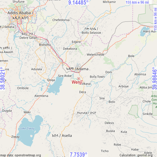
Wenjī GPS coordinates[2]
8° 27' 0" North, 39° 16' 59.988" East
| Map corner | latitude | longitude |
|---|---|---|
| Upper-left | 9.14485°, | 38.58021° |
| Center: | 8.45°, | 39.28333° |
| Lower-right: | 7.7539°, | 39.98646° |
| Map W x H: | 154.7×154.7 km | = 96.1×96.1mi |
| max Lat: | 14.277° ⇑60.7% North |
| Wenjī: | 8.45° |
| min Lat: | ⇓39.3% South 4.05° |
| min Long | Wenjī | max Long |
| 34.53333° | 39.28333° | 42.8° |
| W 71%⇐ | ⇒29% E |
Elevation
Elevation of Wenjī is 1589 m = 5213 ft, and this is 306.6 m = 1006 ft below average elevation for this country.
| Max E: |
2854 m = 9364 ft | 81.3% |
| Avg. | 1895.6 m = 6219 ft | |
| Wenjī | 1589 m = 5213 ft | |
Min E: |
367 m = 1204 ft | 18.7% |
See also: Ethiopia elevation on elevation.city.
Geographical zone
Wenjī is located in North Torrid zone (between Equator and Tropic of Cancer). Distance of Equator is 939.6 km =583.8 mi to South.| Distance of | km | miles | from Wenjī |
|---|---|---|---|
| North Pole | 9067.5 | 5634.3 | to North |
| Arctic Circle | 6461.6 | 4015.1 | to North |
| Tropic Cancer | 1666.4 | 1035.5 | to North |
| Equator | 939.6 | 583.8 | to South |


Nearby cities:
15 places around Wenjī: (largest is in red/bold)
• Addis Ababa
87 km =54.1 mi,  317°
317°
• Bishoftu
47.5 km =29.5 mi, 315°
• Butajīra
107.5 km =66.8 mi,  249°
249°
• Genet
110.1 km =68.4 mi,  308°
308°
• Huruta
34.2 km =21.3 mi,  167°
167°
• Metahāra
85.7 km =53.3 mi,  54°
54°
• Mojo
23.4 km =14.5 mi, 310°
• Nazrēt
11.3 km =7 mi,  350°
350°
• Sebeta
89.8 km =55.8 mi, 305°
• Sendafa
83.1 km =51.6 mi,  339°
339°
• Sirre
26.5 km =16.5 mi,  123°
123°
• Tulu Bolo
119.7 km =74.4 mi,  281°
281°
• Ziway
84.8 km =52.7 mi,  227°
227°
• Ādīs ‘Alem
116.7 km =72.5 mi,  303°
303°
• Āwash
113.8 km =70.7 mi,  58°
58°
Sources, notices
• [Note1] Compared only with cities in Ethiopia existing in our database
• [Src1] Map data: © OpenStreetMap contributors (CC-BY-SA)
• [Src2] Other city data from geonames.org with taken over terms of usage.
• [Src3] Geographical zone / Annual Mean Temperature by Robert A. Rohde @ Wikipedia
