Mojo geodata
Mojo (Oromiya) is a populated place; located in Ethiopia in Africa/Addis_Ababa (GMT+3) time zone. With population of 34,547 people, there are 28 cities with bigger population in this country. Compared to other cities in Ethiopia, 56.1% of cities are located further ↑North; 67.3% of cities are located further ←West and 63.6% of cities have higher elevation than Mojo. Note1


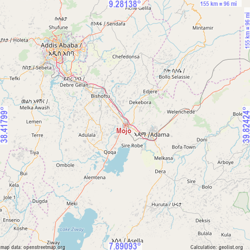
Mojo GPS coordinates[2]
8° 35' 12.444" North, 39° 7' 15.996" East
| Map corner | latitude | longitude |
|---|---|---|
| Upper-left | 9.28138°, | 38.41799° |
| Center: | 8.58679°, | 39.12111° |
| Lower-right: | 7.89093°, | 39.82424° |
| Map W x H: | 154.6×154.6 km | = 96.1×96.1mi |
| max Lat: | 14.277° ⇑56.1% North |
| Mojo: | 8.58679° |
| min Lat: | ⇓43.9% South 4.05° |
| min Long | Mojo | max Long |
| 34.53333° | 39.12111° | 42.8° |
| W 67.3%⇐ | ⇒32.7% E |
Elevation
Elevation of Mojo is 1774 m = 5820 ft, and this is 121.6 m = 399 ft below average elevation for this country.
| Max E: |
2854 m = 9364 ft | 63.6% |
| Avg. | 1895.6 m = 6219 ft | |
| Mojo | 1774 m = 5820 ft | |
Min E: |
367 m = 1204 ft | 36.4% |
See also: Ethiopia elevation on elevation.city.
Geographical zone
Mojo is located in North Torrid zone (between Equator and Tropic of Cancer). Distance of Equator is 954.8 km =593.3 mi to South.| Distance of | km | miles | from Mojo |
|---|---|---|---|
| North Pole | 9052.3 | 5624.8 | to North |
| Arctic Circle | 6446.4 | 4005.6 | to North |
| Tropic Cancer | 1651.2 | 1026 | to North |
| Equator | 954.8 | 593.3 | to South |


Nearby cities:
15 places around Mojo: (largest is in red/bold)
• Addis Ababa
63.8 km =39.6 mi,  319°
319°
• Bishoftu
24.2 km =15 mi, 319°
• Butajīra
98.1 km =61 mi,  237°
237°
• Genet
86.6 km =53.8 mi,  308°
308°
• Huruta
54.7 km =34 mi,  152°
152°
• Metahāra
94.1 km =58.5 mi,  68°
68°
• Nazrēt
16.5 km =10.3 mi,  104°
104°
• Sebeta
66.5 km =41.3 mi,  303°
303°
• Sendafa
63.8 km =39.6 mi,  350°
350°
• Sirre
49.9 km =31 mi,  127°
127°
• Tulu Bolo
99.8 km =62 mi,  275°
275°
• Wenjī
23.4 km =14.5 mi, 130°
• Ziway
85.2 km =52.9 mi,  211°
211°
• Ādīs ‘Alem
93.5 km =58.1 mi, 302°
• Āwash
123.1 km =76.5 mi, 69°
Sources, notices
• [Note1] Compared only with cities in Ethiopia existing in our database
• [Src1] Map data: © OpenStreetMap contributors (CC-BY-SA)
• [Src2] Other city data from geonames.org with taken over terms of usage.
• [Src3] Geographical zone / Annual Mean Temperature by Robert A. Rohde @ Wikipedia
