Sendafa geodata
Sendafa (Oromiya) is a populated place; located in Ethiopia in Africa/Addis_Ababa (GMT+3) time zone. With population of 7,326 people, there are 101 cities with bigger population in this country. Compared to other cities in Ethiopia, 57% of cities are located further ↓South; 65.4% of cities are located further ←West and 89.7% of cities have lower elevation than Sendafa. Note1


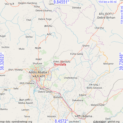
Sendafa GPS coordinates[2]
9° 9' 7.308" North, 39° 1' 24.06" East
| Map corner | latitude | longitude |
|---|---|---|
| Upper-left | 9.84551°, | 38.32023° |
| Center: | 9.15203°, | 39.02335° |
| Lower-right: | 8.4572°, | 39.72648° |
| Map W x H: | 154.4×154.4 km | = 95.9×95.9mi |
| max Lat: | 14.277° ⇑43% North |
| Sendafa: | 9.15203° |
| min Lat: | ⇓57% South 4.05° |
| min Long | Sendafa | max Long |
| 34.53333° | 39.02335° | 42.8° |
| W 65.4%⇐ | ⇒34.6% E |
Elevation
Elevation of Sendafa is 2560 m = 8399 ft, and this is 664.4 m = 2180 ft above average elevation for this country.
| Max E: |
2854 m = 9364 ft | 10.3% |
| Sendafa | 2560 m 8399 ft | |
| Avg. | 1895.6 m = 6219 ft | |
Min E: |
367 m = 1204 ft | 89.7% |
See also: Ethiopia elevation on elevation.city.
Geographical zone
Sendafa is located in North Torrid zone (between Equator and Tropic of Cancer). Distance of Equator is 1017.6 km =632.3 mi to South.| Distance of | km | miles | from Sendafa |
|---|---|---|---|
| North Pole | 8989.5 | 5585.8 | to North |
| Arctic Circle | 6383.6 | 3966.6 | to North |
| Tropic Cancer | 1588.3 | 986.9 | to North |
| Equator | 1017.6 | 632.3 | to South |


Nearby cities:
15 places around Sendafa: (largest is in red/bold)
• Addis Ababa
33.5 km =20.8 mi,  245°
245°
• Bishoftu
44.7 km =27.8 mi,  186°
186°
• Debre Birhan
81 km =50.3 mi,  43°
43°
• Debre Sīna
111.9 km =69.5 mi,  46°
46°
• Fichē
78.8 km =49 mi,  336°
336°
• Gebre Guracha
99.3 km =61.7 mi,  316°
316°
• Genet
58.2 km =36.2 mi,  260°
260°
• Metahāra
102 km =63.4 mi,  105°
105°
• Mojo
63.8 km =39.6 mi,  170°
170°
• Nazrēt
72.1 km =44.8 mi,  158°
158°
• Sebeta
51.8 km =32.2 mi,  239°
239°
• Sirre
105.7 km =65.7 mi,  151°
151°
• Tulu Bolo
103.8 km =64.5 mi, 238°
• Wenjī
83.1 km =51.6 mi, 159°
• Ādīs ‘Alem
69.7 km =43.3 mi, 259°
Sources, notices
• [Note1] Compared only with cities in Ethiopia existing in our database
• [Src1] Map data: © OpenStreetMap contributors (CC-BY-SA)
• [Src2] Other city data from geonames.org with taken over terms of usage.
• [Src3] Geographical zone / Annual Mean Temperature by Robert A. Rohde @ Wikipedia
