Nazrēt geodata
Nazrēt (Oromiya) is a populated place; located in Ethiopia in Africa/Addis_Ababa (GMT+3) time zone. With population of 213,995 people, there are 3 cities with bigger population in this country. Compared to other cities in Ethiopia, 57% of cities are located further ↑North; 70.1% of cities are located further ←West and 76.6% of cities have higher elevation than Nazrēt. Note1


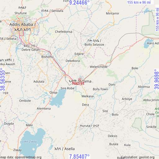
Nazrēt GPS coordinates[2]
8° 33' 0" North, 39° 16' 0.012" East
| Map corner | latitude | longitude |
|---|---|---|
| Upper-left | 9.24466°, | 38.56355° |
| Center: | 8.55°, | 39.26667° |
| Lower-right: | 7.85407°, | 39.9698° |
| Map W x H: | 154.6×154.6 km | = 96.1×96.1mi |
| max Lat: | 14.277° ⇑57% North |
| Nazrēt: | 8.55° |
| min Lat: | ⇓43% South 4.05° |
| min Long | Nazrēt | max Long |
| 34.53333° | 39.26667° | 42.8° |
| W 70.1%⇐ | ⇒29.9% E |
Elevation
Elevation of Nazrēt is 1627 m = 5338 ft, and this is 268.6 m = 881 ft below average elevation for this country.
| Max E: |
2854 m = 9364 ft | 76.6% |
| Avg. | 1895.6 m = 6219 ft | |
| Nazrēt | 1627 m = 5338 ft | |
Min E: |
367 m = 1204 ft | 23.4% |
See also: Nazrēt elevation on elevation.city.
Geographical zone
Nazrēt is located in North Torrid zone (between Equator and Tropic of Cancer). Distance of Equator is 950.7 km =590.7 mi to South.| Distance of | km | miles | from Nazrēt |
|---|---|---|---|
| North Pole | 9056.4 | 5627.4 | to North |
| Arctic Circle | 6450.5 | 4008.2 | to North |
| Tropic Cancer | 1655.2 | 1028.5 | to North |
| Equator | 950.7 | 590.7 | to South |


Nearby cities:
15 places around Nazrēt: (largest is in red/bold)
• Addis Ababa
77.8 km =48.3 mi,  312°
312°
• Bishoftu
38.9 km =24.2 mi, 305°
• Butajīra
110.1 km =68.4 mi,  244°
244°
• Genet
102 km =63.4 mi,  304°
304°
• Huruta
45.4 km =28.2 mi,  168°
168°
• Metahāra
81.3 km =50.5 mi,  61°
61°
• Mojo
16.5 km =10.3 mi,  284°
284°
• Sebeta
82.3 km =51.1 mi, 299°
• Sendafa
72.1 km =44.8 mi,  338°
338°
• Sirre
35.2 km =21.9 mi,  137°
137°
• Tulu Bolo
116.2 km =72.2 mi, 276°
• Wenjī
11.3 km =7 mi, 170°
• Ziway
91.5 km =56.9 mi,  221°
221°
• Ādīs ‘Alem
109.3 km =67.9 mi, 299°
• Āwash
110 km =68.4 mi, 64°
Sources, notices
• [Note1] Compared only with cities in Ethiopia existing in our database
• [Src1] Map data: © OpenStreetMap contributors (CC-BY-SA)
• [Src2] Other city data from geonames.org with taken over terms of usage.
• [Src3] Geographical zone / Annual Mean Temperature by Robert A. Rohde @ Wikipedia
