Āsasa geodata
Āsasa (Oromiya) is a populated place; located in Ethiopia in Africa/Addis_Ababa (GMT+3) time zone. With population of 23,790 people, there are 54 cities with bigger population in this country. Compared to other cities in Ethiopia, 75.7% of cities are located further ↑North; 69.2% of cities are located further ←West and 75.7% of cities have lower elevation than Āsasa. Note1


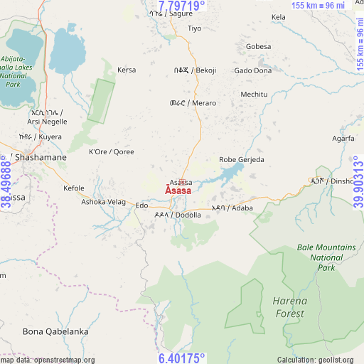
Āsasa GPS coordinates[2]
7° 6' 0" North, 39° 12' 0" East
| Map corner | latitude | longitude |
|---|---|---|
| Upper-left | 7.79719°, | 38.49688° |
| Center: | 7.1°, | 39.2° |
| Lower-right: | 6.40175°, | 39.90313° |
| Map W x H: | 155.2×155.2 km | = 96.4×96.4mi |
| max Lat: | 14.277° ⇑75.7% North |
| Āsasa: | 7.1° |
| min Lat: | ⇓24.3% South 4.05° |
| min Long | Āsasa | max Long |
| 34.53333° | 39.2° | 42.8° |
| W 69.2%⇐ | ⇒30.8% E |
Elevation
Elevation of Āsasa is 2369 m = 7772 ft, and this is 473.4 m = 1553 ft above average elevation for this country.
| Max E: |
2854 m = 9364 ft | 24.3% |
| Āsasa | 2369 m 7772 ft | |
| Avg. | 1895.6 m = 6219 ft | |
Min E: |
367 m = 1204 ft | 75.7% |
See also: Ethiopia elevation on elevation.city.
Geographical zone
Āsasa is located in North Torrid zone (between Equator and Tropic of Cancer). Distance of Equator is 789.4 km =490.5 mi to South.| Distance of | km | miles | from Āsasa |
|---|---|---|---|
| North Pole | 9217.6 | 5727.5 | to North |
| Arctic Circle | 6611.7 | 4108.3 | to North |
| Tropic Cancer | 1816.5 | 1128.7 | to North |
| Equator | 789.4 | 490.5 | to South |


Nearby cities:
15 places around Āsasa: (largest is in red/bold)
• Dodola
13.1 km =8.1 mi,  188°
188°
• Dīla
123.6 km =76.8 mi,  232°
232°
• Goba
86.9 km =54 mi,  96°
96°
• Hawassa
80 km =49.7 mi,  266°
266°
• Huruta
117.9 km =73.3 mi,  8°
8°
• Hāgere Selam
101.9 km =63.3 mi, 227°
• Kibre Mengist
137.4 km =85.4 mi, 190°
• Kofelē
46.1 km =28.6 mi, 265°
• K’olīto
125.5 km =78 mi,  281°
281°
• Leku
87.1 km =54.1 mi,  253°
253°
• Shashemenē
67.1 km =41.7 mi, 279°
• Sirre
138.8 km =86.2 mi, 12°
• Wendo
102.8 km =63.9 mi,  237°
237°
• Yirga ‘Alem
94.8 km =58.9 mi, 245°
• Ziway
106.9 km =66.4 mi,  330°
330°
Sources, notices
• [Note1] Compared only with cities in Ethiopia existing in our database
• [Src1] Map data: © OpenStreetMap contributors (CC-BY-SA)
• [Src2] Other city data from geonames.org with taken over terms of usage.
• [Src3] Geographical zone / Annual Mean Temperature by Robert A. Rohde @ Wikipedia
