Hāgere Selam geodata
Hāgere Selam (SNNPR) is a populated place; located in Ethiopia in Africa/Addis_Ababa (GMT+3) time zone. With population of 5,169 people, there are 103 cities with bigger population in this country. Compared to other cities in Ethiopia, 86.9% of cities are located further ↑North; 55.1% of cities are located further ←West and 97.2% of cities have lower elevation than Hāgere Selam. Note1


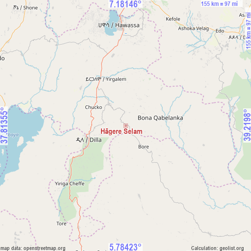
Hāgere Selam GPS coordinates[2]
6° 28' 59.988" North, 38° 31' 0.012" East
| Map corner | latitude | longitude |
|---|---|---|
| Upper-left | 7.18146°, | 37.81355° |
| Center: | 6.48333°, | 38.51667° |
| Lower-right: | 5.78423°, | 39.2198° |
| Map W x H: | 155.4×155.4 km | = 96.6×96.6mi |
| max Lat: | 14.277° ⇑86.9% North |
| Hāgere Selam: | 6.48333° |
| min Lat: | ⇓13.1% South 4.05° |
| min Long | Hāgere Selam | max Long |
| 34.53333° | 38.51667° | 42.8° |
| W 55.1%⇐ | ⇒44.9% E |
Elevation
Elevation of Hāgere Selam is 2746 m = 9009 ft, and this is 850.4 m = 2790 ft above average elevation for this country.
| Max E: |
2854 m = 9364 ft | 2.8% |
| Hāgere Selam | 2746 m 9009 ft | |
| Avg. | 1895.6 m = 6219 ft | |
Min E: |
367 m = 1204 ft | 97.2% |
See also: Ethiopia elevation on elevation.city.
Geographical zone
Hāgere Selam is located in North Torrid zone (between Equator and Tropic of Cancer). Distance of Equator is 720.9 km =447.9 mi to South.| Distance of | km | miles | from Hāgere Selam |
|---|---|---|---|
| North Pole | 9286.2 | 5770.2 | to North |
| Arctic Circle | 6680.3 | 4150.9 | to North |
| Tropic Cancer | 1885 | 1171.3 | to North |
| Equator | 720.9 | 447.9 | to South |


Nearby cities:
15 places around Hāgere Selam: (largest is in red/bold)
• Bodītī
89.7 km =55.7 mi,  306°
306°
• Dodola
92.2 km =57.3 mi,  52°
52°
• Dīla
23.3 km =14.5 mi,  251°
251°
• Hagere Maryam
99.4 km =61.8 mi,  198°
198°
• Hawassa
64.5 km =40.1 mi,  356°
356°
• Kibre Mengist
84.3 km =52.4 mi,  142°
142°
• Kofelē
71.2 km =44.2 mi,  24°
24°
• K’olīto
104.3 km =64.8 mi,  332°
332°
• Leku
44.1 km =27.4 mi,  349°
349°
• Shakiso
90.9 km =56.5 mi,  151°
151°
• Shashemenē
80.2 km =49.8 mi,  6°
6°
• Sodo
93.3 km =58 mi,  296°
296°
• Wendo
17 km =10.6 mi,  319°
319°
• Yirga ‘Alem
31.6 km =19.6 mi,  339°
339°
• Āsasa
101.9 km =63.3 mi, 47°
Sources, notices
• [Note1] Compared only with cities in Ethiopia existing in our database
• [Src1] Map data: © OpenStreetMap contributors (CC-BY-SA)
• [Src2] Other city data from geonames.org with taken over terms of usage.
• [Src3] Geographical zone / Annual Mean Temperature by Robert A. Rohde @ Wikipedia
