Sirre geodata
Sirre (Oromiya) is a populated place; located in Ethiopia in Africa/Addis_Ababa (GMT+3) time zone. With population of 10,089 people, there are 93 cities with bigger population in this country. Compared to other cities in Ethiopia, 61.7% of cities are located further ↑North; 75.7% of cities are located further ←West and 64.5% of cities have higher elevation than Sirre. Note1


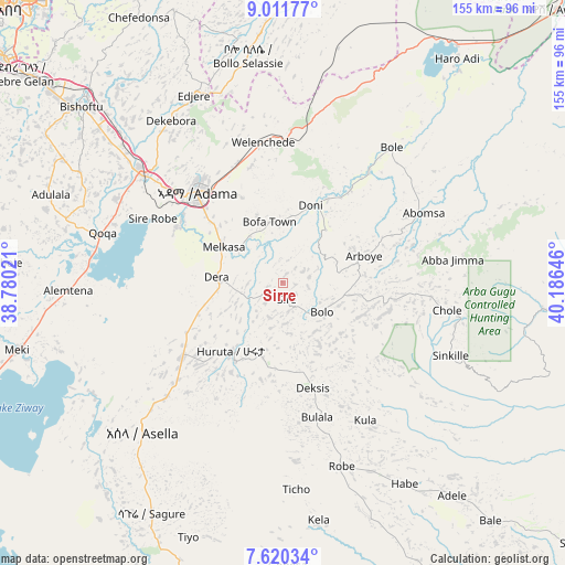
Sirre GPS coordinates[2]
8° 19' 0.012" North, 39° 28' 59.988" East
| Map corner | latitude | longitude |
|---|---|---|
| Upper-left | 9.01177°, | 38.78021° |
| Center: | 8.31667°, | 39.48333° |
| Lower-right: | 7.62034°, | 40.18646° |
| Map W x H: | 154.7×154.7 km | = 96.1×96.1mi |
| max Lat: | 14.277° ⇑61.7% North |
| Sirre: | 8.31667° |
| min Lat: | ⇓38.3% South 4.05° |
| min Long | Sirre | max Long |
| 34.53333° | 39.48333° | 42.8° |
| W 75.7%⇐ | ⇒24.3% E |
Elevation
Elevation of Sirre is 1755 m = 5758 ft, and this is 140.6 m = 461 ft below average elevation for this country.
| Max E: |
2854 m = 9364 ft | 64.5% |
| Avg. | 1895.6 m = 6219 ft | |
| Sirre | 1755 m = 5758 ft | |
Min E: |
367 m = 1204 ft | 35.5% |
See also: Ethiopia elevation on elevation.city.
Geographical zone
Sirre is located in North Torrid zone (between Equator and Tropic of Cancer). Distance of Equator is 924.7 km =574.6 mi to South.| Distance of | km | miles | from Sirre |
|---|---|---|---|
| North Pole | 9082.3 | 5643.5 | to North |
| Arctic Circle | 6476.4 | 4024.2 | to North |
| Tropic Cancer | 1681.2 | 1044.6 | to North |
| Equator | 924.7 | 574.6 | to South |


Nearby cities:
15 places around Sirre: (largest is in red/bold)
• Addis Ababa
112.9 km =70.2 mi,  314°
314°
• Bishoftu
73.7 km =45.8 mi, 311°
• Butajīra
124.9 km =77.6 mi,  259°
259°
• Gelemso
126.5 km =78.6 mi,  63°
63°
• Genet
136.5 km =84.8 mi, 307°
• Huruta
23.6 km =14.7 mi,  218°
218°
• Metahāra
80.5 km =50 mi,  36°
36°
• Mojo
49.9 km =31 mi, 307°
• Nazrēt
35.2 km =21.9 mi,  317°
317°
• Sebeta
116.3 km =72.3 mi, 305°
• Sendafa
105.7 km =65.7 mi,  331°
331°
• Wenjī
26.5 km =16.5 mi,  303°
303°
• Ziway
94.5 km =58.7 mi,  243°
243°
• Āsasa
138.8 km =86.2 mi,  192°
192°
• Āwash
105.5 km =65.6 mi,  45°
45°
Sources, notices
• [Note1] Compared only with cities in Ethiopia existing in our database
• [Src1] Map data: © OpenStreetMap contributors (CC-BY-SA)
• [Src2] Other city data from geonames.org with taken over terms of usage.
• [Src3] Geographical zone / Annual Mean Temperature by Robert A. Rohde @ Wikipedia
