Nejo geodata
Nejo (Oromiya) is a populated place; located in Ethiopia in Africa/Addis_Ababa (GMT+3) time zone. With population of 20,166 people, there are 66 cities with bigger population in this country. Compared to other cities in Ethiopia, 62.6% of cities are located further ↓South; 95.3% of cities are located further →East and 52.3% of cities have higher elevation than Nejo. Note1


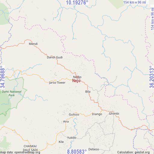
Nejo GPS coordinates[2]
9° 30' 0" North, 35° 30' 0" East
| Map corner | latitude | longitude |
|---|---|---|
| Upper-left | 10.19276°, | 34.79688° |
| Center: | 9.5°, | 35.5° |
| Lower-right: | 8.80583°, | 36.20313° |
| Map W x H: | 154.2×154.2 km | = 95.8×95.8mi |
| max Lat: | 14.277° ⇑37.4% North |
| Nejo: | 9.5° |
| min Lat: | ⇓62.6% South 4.05° |
| min Long | Nejo | max Long |
| 34.53333° | 35.5° | 42.8° |
| W 4.7%⇐ | ⇒95.3% E |
Elevation
Elevation of Nejo is 1888 m = 6194 ft, and this is 7.5999999999999 m = 25 ft below average elevation for this country.
| Max E: |
2854 m = 9364 ft | 52.3% |
| Avg. | 1895.6 m = 6219 ft | |
| Nejo | 1888 m = 6194 ft | |
Min E: |
367 m = 1204 ft | 47.7% |
See also: Ethiopia elevation on elevation.city.
Geographical zone
Nejo is located in North Torrid zone (between Equator and Tropic of Cancer). Distance of Equator is 1056.3 km =656.4 mi to South.| Distance of | km | miles | from Nejo |
|---|---|---|---|
| North Pole | 8950.8 | 5561.8 | to North |
| Arctic Circle | 6344.9 | 3942.5 | to North |
| Tropic Cancer | 1549.6 | 962.9 | to North |
| Equator | 1056.3 | 656.4 | to South |


Nearby cities:
15 places around Nejo: (largest is in red/bold)
• Bedelē
149.2 km =92.7 mi,  141°
141°
• Burē
217.3 km =135 mi,  52°
52°
• Dembī Dolo
132.1 km =82.1 mi,  215°
215°
• Finote Selam
234.9 km =146 mi,  55°
55°
• Gambēla
171.6 km =106.6 mi, 215°
• Gimbi
51.9 km =32.2 mi,  134°
134°
• Gorē
150.2 km =93.3 mi,  178°
178°
• Gēdo
220.6 km =137.1 mi,  104°
104°
• Jimma
250.5 km =155.7 mi, 144°
• Mendī
55.1 km =34.2 mi,  307°
307°
• Metu
133.7 km =83.1 mi, 176°
• Shambu
175.6 km =109.1 mi,  87°
87°
• Tippi
255.8 km =158.9 mi, 181°
• Āgaro
222.8 km =138.4 mi,  145°
145°
• Āsosa
123.2 km =76.6 mi,  300°
300°
Sources, notices
• [Note1] Compared only with cities in Ethiopia existing in our database
• [Src1] Map data: © OpenStreetMap contributors (CC-BY-SA)
• [Src2] Other city data from geonames.org with taken over terms of usage.
• [Src3] Geographical zone / Annual Mean Temperature by Robert A. Rohde @ Wikipedia
