Dembī Dolo geodata
Dembī Dolo (Oromiya) is a populated place; located in Ethiopia in Africa/Addis_Ababa (GMT+3) time zone. With population of 26,748 people, there are 46 cities with bigger population in this country. Compared to other cities in Ethiopia, 58.9% of cities are located further ↑North; 98.1% of cities are located further →East and 56.1% of cities have higher elevation than Dembī Dolo. Note1


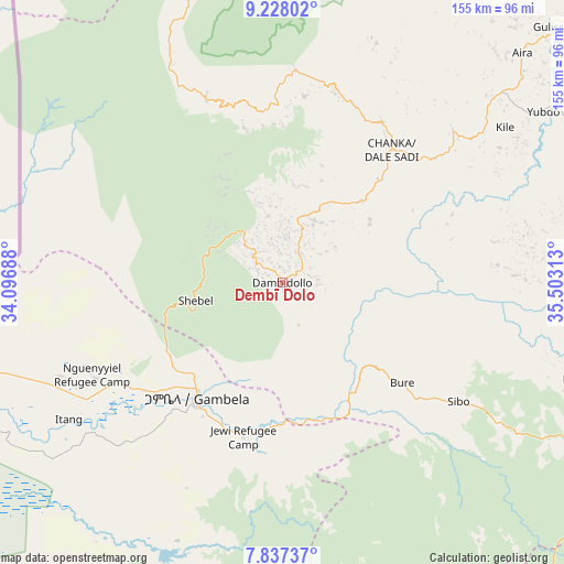
Dembī Dolo GPS coordinates[2]
8° 31' 59.988" North, 34° 48' 0" East
| Map corner | latitude | longitude |
|---|---|---|
| Upper-left | 9.22802°, | 34.09688° |
| Center: | 8.53333°, | 34.8° |
| Lower-right: | 7.83737°, | 35.50313° |
| Map W x H: | 154.6×154.6 km | = 96.1×96.1mi |
| max Lat: | 14.277° ⇑58.9% North |
| Dembī Dolo: | 8.53333° |
| min Lat: | ⇓41.1% South 4.05° |
| min Long | Dembī Dolo | max Long |
| 34.53333° | 34.8° | 42.8° |
| W 1.9%⇐ | ⇒98.1% E |
Elevation
Elevation of Dembī Dolo is 1847 m = 6060 ft, and this is 48.6 m = 159 ft below average elevation for this country.
| Max E: |
2854 m = 9364 ft | 56.1% |
| Avg. | 1895.6 m = 6219 ft | |
| Dembī Dolo | 1847 m = 6060 ft | |
Min E: |
367 m = 1204 ft | 43.9% |
See also: Ethiopia elevation on elevation.city.
Geographical zone
Dembī Dolo is located in North Torrid zone (between Equator and Tropic of Cancer). Distance of Equator is 948.8 km =589.6 mi to South.| Distance of | km | miles | from Dembī Dolo |
|---|---|---|---|
| North Pole | 9058.2 | 5628.5 | to North |
| Arctic Circle | 6452.4 | 4009.3 | to North |
| Tropic Cancer | 1657.1 | 1029.7 | to North |
| Equator | 948.8 | 589.6 | to South |


Nearby cities:
15 places around Dembī Dolo: (largest is in red/bold)
• Bedelē
171 km =106.3 mi,  92°
92°
• Bonga
210.3 km =130.7 mi,  131°
131°
• Gambēla
39.5 km =24.5 mi,  217°
217°
• Gimbi
134 km =83.3 mi,  58°
58°
• Gorē
91.2 km =56.7 mi,  117°
117°
• Gēdo
296.1 km =184 mi,  79°
79°
• Jimma
243.5 km =151.3 mi,  113°
113°
• Mendī
144.6 km =89.9 mi,  13°
13°
• Metu
90 km =55.9 mi, 106°
• Mīzan Teferī
191.5 km =119 mi,  153°
153°
• Nejo
132.1 km =82.1 mi,  35°
35°
• Shambu
277.5 km =172.4 mi,  65°
65°
• Tippi
164.6 km =102.3 mi, 154°
• Āgaro
217.3 km =135 mi, 110°
• Āsosa
173 km =107.5 mi,  350°
350°
Sources, notices
• [Note1] Compared only with cities in Ethiopia existing in our database
• [Src1] Map data: © OpenStreetMap contributors (CC-BY-SA)
• [Src2] Other city data from geonames.org with taken over terms of usage.
• [Src3] Geographical zone / Annual Mean Temperature by Robert A. Rohde @ Wikipedia
