Ventavon geodata
Ventavon (Provence-Alpes-Côte d'Azur) is a populated place; located in France in Europe/Paris (GMT+2) time zone. With population of 558 people, there are 14045 cities with bigger population in this country. Compared to other cities in France, 84.4% of cities are located further ↑North; 86% of cities are located further ←West and 96.4% of cities have lower elevation than Ventavon. Note1
Administrative division(s):
- Level 1: Provence-Alpes-Côte d'Azur
- Level 2: Hautes-Alpes
- Level 3: Arrondissement de Gap
- Level 4: Ventavon


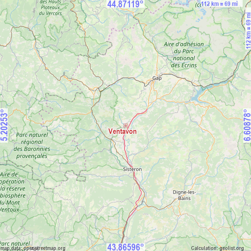
Ventavon GPS coordinates[2]
44° 22' 14.628" North, 5° 54' 20.34" East
| Map corner | latitude | longitude |
|---|---|---|
| Upper-left | 44.87119°, | 5.20253° |
| Center: | 44.37073°, | 5.90565° |
| Lower-right: | 43.86596°, | 6.60878° |
| Map W x H: | 111.8×111.8 km | = 69.5×69.5mi |
| max Lat: | 51.07786° ⇑84.4% North |
| Ventavon: | 44.37073° |
| min Lat: | ⇓15.6% South 41.3874° |
| min Long | Ventavon | max Long |
| -5.08615° | 5.90565° | 9.52242° |
| W 86%⇐ | ⇒14% E |
Elevation
Elevation of Ventavon is 673 m = 2208 ft, and this is 479.3 m = 1573 ft above average elevation for this country.
| Max E: |
2333 m = 7654 ft | 3.6% |
| Ventavon | 673 m 2208 ft | |
| Avg. | 193.7 m = 635 ft | |
Min E: |
-1 m = -3 ft | 96.4% |
See also: France elevation on elevation.city.
Geographical zone
Ventavon is located in North temperate zone (between Tropic of Cancer and the Arctic Circle). Distance of this Northern Tropic circle is 2327.6 km =1446.3 mi to South.| Distance of | km | miles | from Ventavon |
|---|---|---|---|
| North Pole | 5073.5 | 3152.5 | to North |
| Arctic Circle | 2467.6 | 1533.3 | to North |
| Tropic Cancer | 2327.6 | 1446.3 | to South |
| Equator | 4933.6 | 3065.6 | to South |


Nearby cities:
15 places around Ventavon: (largest is in red/bold)
• Aspres-sur-Buëch
20.8 km =12.9 mi,  324°
324°
• Gap
25 km =15.5 mi,  33°
33°
• La Motte-du-Caire
10.2 km =6.3 mi,  106°
106°
• La Roche-des-Arnauds
21.6 km =13.4 mi,  10°
10°
• La Saulce
10.1 km =6.3 mi,  52°
52°
• Laragne-Montéglin
9.3 km =5.8 mi,  229°
229°
• Mison
12.9 km =8 mi,  203°
203°
• Neffes
17.5 km =10.9 mi, 31°
• Peipin
26.2 km =16.3 mi,  170°
170°
• Ribiers
16 km =9.9 mi,  194°
194°
• Serres
16.4 km =10.2 mi,  292°
292°
• Sigoyer
13.2 km =8.2 mi, 25°
• Sisteron
20.4 km =12.7 mi, 170°
• Tallard
15.4 km =9.6 mi, 48°
• Veynes
19.3 km =12 mi,  340°
340°
Sources, notices
• [Note1] Compared only with cities in France existing in our database
• [Src1] Map data: © OpenStreetMap contributors (CC-BY-SA)
• [Src2] Other city data from geonames.org with taken over terms of usage.
• [Src3] Geographical zone / Annual Mean Temperature by Robert A. Rohde @ Wikipedia
