Oyem geodata
Oyem (Woleu-Ntem) is a seat of a first-order administrative division; located in Gabon in Africa/Libreville (GMT+1) time zone. With population of 30,870 people, there are 3 cities with bigger population in this country. Compared to other cities in Gabon, 96.2% of cities are located further ↓South; 57.7% of cities are located further ←West and 96.2% of cities have lower elevation than Oyem. Note1


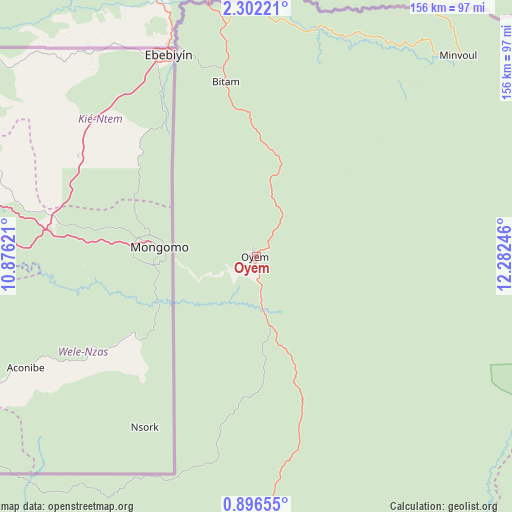
Oyem GPS coordinates[2]
1° 35' 58.2" North, 11° 34' 45.588" East
| Map corner | latitude | longitude |
|---|---|---|
| Upper-left | 2.30221°, | 10.87621° |
| Center: | 1.5995°, | 11.57933° |
| Lower-right: | 0.89655°, | 12.28246° |
| Map W x H: | 156.3×156.3 km | = 97.1×97.1mi |
| max Lat: | 2.07597° ⇑3.8% North |
| Oyem: | 1.5995° |
| min Lat: | ⇓96.2% South -3.43198° |
| min Long | Oyem | max Long |
| 8.78151° | 11.57933° | 14.25905° |
| W 57.7%⇐ | ⇒42.3% E |
Elevation
Elevation of Oyem is 656 m = 2152 ft, and this is 399 m = 1309 ft above average elevation for this country.
| Max E: |
667 m = 2188 ft | 3.8% |
| Oyem | 656 m 2152 ft | |
| Avg. | 257 m = 843 ft | |
Min E: |
4 m = 13 ft | 96.2% |
See also: Gabon elevation on elevation.city.
Geographical zone
Oyem is located in North Torrid zone (between Equator and Tropic of Cancer). Distance of Equator is 177.8 km =110.5 mi to South.| Distance of | km | miles | from Oyem |
|---|---|---|---|
| North Pole | 9829.2 | 6107.6 | to North |
| Arctic Circle | 7223.3 | 4488.3 | to North |
| Tropic Cancer | 2428.1 | 1508.8 | to North |
| Equator | 177.8 | 110.5 | to South |


Nearby cities:
15 places around Oyem: (largest is in red/bold)
• Bitam
53.7 km =33.4 mi,  350°
350°
• Booué
192.3 km =119.5 mi,  168°
168°
• Cocobeach
231.8 km =144 mi,  253°
253°
• Fougamou
332 km =206.3 mi,  199°
199°
• Koulamoutou
319.7 km =198.7 mi,  162°
162°
• Lambaréné
295.9 km =183.9 mi,  210°
210°
• Lastoursville
296.6 km =184.3 mi,  154°
154°
• Libreville
271.8 km =168.9 mi,  240°
240°
• Makokou
182.8 km =113.6 mi,  128°
128°
• Mimongo
357.9 km =222.4 mi,  179°
179°
• Mitzic
91 km =56.5 mi, 182°
• Mounana
377.7 km =234.7 mi, 152°
• Ndjolé
217.4 km =135.1 mi, 204°
• Ntoum
242.8 km =150.9 mi, 236°
• Okondja
342.2 km =212.6 mi,  137°
137°
Sources, notices
• [Note1] Compared only with cities in Gabon existing in our database
• [Src1] Map data: © OpenStreetMap contributors (CC-BY-SA)
• [Src2] Other city data from geonames.org with taken over terms of usage.
• [Src3] Geographical zone / Annual Mean Temperature by Robert A. Rohde @ Wikipedia
