Cocobeach geodata
Cocobeach (Estuaire) is a populated place; located in Gabon in Africa/Libreville (GMT+1) time zone. With population of 1,653 people, there are 26 cities with bigger population in this country. Compared to other cities in Gabon, 92.3% of cities are located further ↓South; 88.5% of cities are located further →East and 80.8% of cities have higher elevation than Cocobeach. Note1


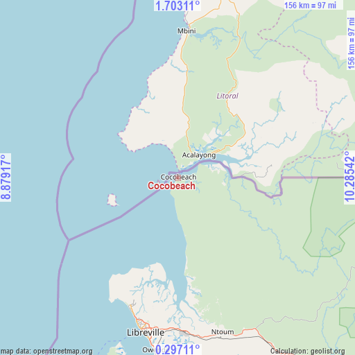
Cocobeach GPS coordinates[2]
1° 0' 0.684" North, 9° 34' 56.244" East
| Map corner | latitude | longitude |
|---|---|---|
| Upper-left | 1.70311°, | 8.87917° |
| Center: | 1.00019°, | 9.58229° |
| Lower-right: | 0.29711°, | 10.28542° |
| Map W x H: | 156.3×156.3 km | = 97.1×97.1mi |
| max Lat: | 2.07597° ⇑7.7% North |
| Cocobeach: | 1.00019° |
| min Lat: | ⇓92.3% South -3.43198° |
| min Long | Cocobeach | max Long |
| 8.78151° | 9.58229° | 14.25905° |
| W 11.5%⇐ | ⇒88.5% E |
Elevation
Elevation of Cocobeach is 18 m = 59 ft, and this is 239 m = 784 ft below average elevation for this country.
| Max E: |
667 m = 2188 ft | 80.8% |
| Avg. | 257 m = 843 ft | |
| Cocobeach | 18 m = 59 ft | |
Min E: |
4 m = 13 ft | 19.2% |
See also: Gabon elevation on elevation.city.
Geographical zone
Cocobeach is located in North Torrid zone (between Equator and Tropic of Cancer). Distance of Equator is 111.2 km =69.1 mi to South.| Distance of | km | miles | from Cocobeach |
|---|---|---|---|
| North Pole | 9895.9 | 6149 | to North |
| Arctic Circle | 7290 | 4529.8 | to North |
| Tropic Cancer | 2494.7 | 1550.1 | to North |
| Equator | 111.2 | 69.1 | to South |


Nearby cities:
15 places around Cocobeach: (largest is in red/bold)
• Bitam
244.5 km =151.9 mi,  60°
60°
• Booué
288.8 km =179.5 mi,  114°
114°
• Fougamou
270.4 km =168 mi,  155°
155°
• Koulamoutou
398.9 km =247.9 mi,  126°
126°
• Lambaréné
202.7 km =126 mi, 158°
• Libreville
69.1 km =42.9 mi,  191°
191°
• Makokou
367.9 km =228.6 mi,  97°
97°
• Mimongo
368.1 km =228.7 mi,  142°
142°
• Mitzic
220 km =136.7 mi, 96°
• Mouila
358.6 km =222.8 mi,  152°
152°
• Ndjolé
185.6 km =115.3 mi, 134°
• Ntoum
70.6 km =43.9 mi, 163°
• Omboué
288.5 km =179.3 mi, 187°
• Oyem
231.8 km =144 mi,  73°
73°
• Port-Gentil
210.9 km =131 mi,  204°
204°
Sources, notices
• [Note1] Compared only with cities in Gabon existing in our database
• [Src1] Map data: © OpenStreetMap contributors (CC-BY-SA)
• [Src2] Other city data from geonames.org with taken over terms of usage.
• [Src3] Geographical zone / Annual Mean Temperature by Robert A. Rohde @ Wikipedia
