Libreville geodata
Libreville (Estuaire) is a capital of a political entity; located in Gabon in Africa/Libreville (GMT+1) time zone. With population of 578,156 people, there are 0 cities with bigger population in this country. Compared to other cities in Gabon, 80.8% of cities are located further ↓South; 92.3% of cities are located further →East and 96.2% of cities have higher elevation than Libreville. Note1


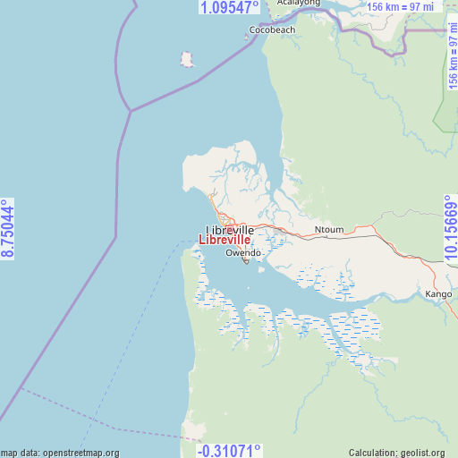
Libreville GPS coordinates[2]
0° 23' 32.676" North, 9° 27' 12.816" East
| Map corner | latitude | longitude |
|---|---|---|
| Upper-left | 1.09547°, | 8.75044° |
| Center: | 0.39241°, | 9.45356° |
| Lower-right: | -0.31071°, | 10.15669° |
| Map W x H: | 156.4×156.4 km | = 97.2×97.2mi |
| max Lat: | 2.07597° ⇑19.2% North |
| Libreville: | 0.39241° |
| min Lat: | ⇓80.8% South -3.43198° |
| min Long | Libreville | max Long |
| 8.78151° | 9.45356° | 14.25905° |
| W 7.7%⇐ | ⇒92.3% E |
Elevation
Elevation of Libreville is 8 m = 26 ft, and this is 249 m = 817 ft below average elevation for this country.
| Max E: |
667 m = 2188 ft | 96.2% |
| Avg. | 257 m = 843 ft | |
| Libreville | 8 m = 26 ft | |
Min E: |
4 m = 13 ft | 3.8% |
See also: Libreville elevation on elevation.city.
Geographical zone
Libreville is located in North Torrid zone (between Equator and Tropic of Cancer). Distance of Equator is 43.6 km =27.1 mi to South.| Distance of | km | miles | from Libreville |
|---|---|---|---|
| North Pole | 9963.4 | 6191 | to North |
| Arctic Circle | 7357.5 | 4571.7 | to North |
| Tropic Cancer | 2562.3 | 1592.1 | to North |
| Equator | 43.6 | 27.1 | to South |


Nearby cities:
15 places around Libreville: (largest is in red/bold)
• Bitam
294.7 km =183.1 mi,  50°
50°
• Booué
281.5 km =174.9 mi,  101°
101°
• Cocobeach
69.1 km =42.9 mi,  11°
11°
• Fougamou
218.5 km =135.8 mi,  144°
144°
• Gamba
343.7 km =213.6 mi,  169°
169°
• Lambaréné
149.7 km =93 mi, 144°
• Mbigou
373.3 km =232 mi,  133°
133°
• Mimongo
327.6 km =203.6 mi, 133°
• Mitzic
237 km =147.3 mi,  79°
79°
• Mouila
308.1 km =191.4 mi, 144°
• Ndjolé
159 km =98.8 mi,  113°
113°
• Ntoum
34.2 km =21.3 mi,  90°
90°
• Omboué
219.8 km =136.6 mi,  185°
185°
• Oyem
271.8 km =168.9 mi,  60°
60°
• Port-Gentil
144.4 km =89.7 mi,  211°
211°
Sources, notices
• [Note1] Compared only with cities in Gabon existing in our database
• [Src1] Map data: © OpenStreetMap contributors (CC-BY-SA)
• [Src2] Other city data from geonames.org with taken over terms of usage.
• [Src3] Geographical zone / Annual Mean Temperature by Robert A. Rohde @ Wikipedia
