Ntoum geodata
Ntoum (Estuaire) is a populated place; located in Gabon in Africa/Libreville (GMT+1) time zone. With population of 8,569 people, there are 13 cities with bigger population in this country. Compared to other cities in Gabon, 76.9% of cities are located further ↓South; 84.6% of cities are located further →East and 88.5% of cities have higher elevation than Ntoum. Note1


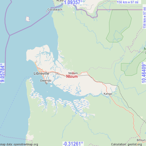
Ntoum GPS coordinates[2]
0° 23' 25.836" North, 9° 45' 39.456" East
| Map corner | latitude | longitude |
|---|---|---|
| Upper-left | 1.09357°, | 9.05784° |
| Center: | 0.39051°, | 9.76096° |
| Lower-right: | -0.31261°, | 10.46409° |
| Map W x H: | 156.4×156.4 km | = 97.2×97.2mi |
| max Lat: | 2.07597° ⇑23.1% North |
| Ntoum: | 0.39051° |
| min Lat: | ⇓76.9% South -3.43198° |
| min Long | Ntoum | max Long |
| 8.78151° | 9.76096° | 14.25905° |
| W 15.4%⇐ | ⇒84.6% E |
Elevation
Elevation of Ntoum is 11 m = 36 ft, and this is 246 m = 807 ft below average elevation for this country.
| Max E: |
667 m = 2188 ft | 88.5% |
| Avg. | 257 m = 843 ft | |
| Ntoum | 11 m = 36 ft | |
Min E: |
4 m = 13 ft | 11.5% |
See also: Gabon elevation on elevation.city.
Geographical zone
Ntoum is located in North Torrid zone (between Equator and Tropic of Cancer). Distance of Equator is 43.4 km =27 mi to South.| Distance of | km | miles | from Ntoum |
|---|---|---|---|
| North Pole | 9963.6 | 6191.1 | to North |
| Arctic Circle | 7357.8 | 4571.9 | to North |
| Tropic Cancer | 2562.5 | 1592.3 | to North |
| Equator | 43.4 | 27 | to South |


Nearby cities:
15 places around Ntoum: (largest is in red/bold)
• Bitam
269.3 km =167.3 mi,  45°
45°
• Booué
248 km =154.1 mi,  102°
102°
• Cocobeach
70.6 km =43.9 mi,  343°
343°
• Fougamou
200.6 km =124.6 mi,  152°
152°
• Gamba
339.1 km =210.7 mi,  175°
175°
• Koulamoutou
345.2 km =214.5 mi,  119°
119°
• Lambaréné
132.5 km =82.3 mi,  156°
156°
• Libreville
34.2 km =21.3 mi,  270°
270°
• Mimongo
303.4 km =188.5 mi,  137°
137°
• Mitzic
203.5 km =126.4 mi,  77°
77°
• Mouila
289.5 km =179.9 mi, 150°
• Ndjolé
128.3 km =79.7 mi, 119°
• Omboué
225.4 km =140.1 mi,  194°
194°
• Oyem
242.8 km =150.9 mi,  56°
56°
• Port-Gentil
164.6 km =102.3 mi,  221°
221°
Sources, notices
• [Note1] Compared only with cities in Gabon existing in our database
• [Src1] Map data: © OpenStreetMap contributors (CC-BY-SA)
• [Src2] Other city data from geonames.org with taken over terms of usage.
• [Src3] Geographical zone / Annual Mean Temperature by Robert A. Rohde @ Wikipedia
