Lastoursville geodata
Lastoursville (Ogooué-Lolo) is a populated place; located in Gabon in Africa/Libreville (GMT+1) time zone. With population of 8,340 people, there are 14 cities with bigger population in this country. Compared to other cities in Gabon, 53.8% of cities are located further ↓South; 76.9% of cities are located further ←West and 53.8% of cities have lower elevation than Lastoursville. Note1


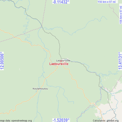
Lastoursville GPS coordinates[2]
0° 49' 2.712" South, 12° 42' 29.448" East
| Map corner | latitude | longitude |
|---|---|---|
| Upper-left | -0.11432°, | 12.00506° |
| Center: | -0.81742°, | 12.70818° |
| Lower-right: | -1.52039°, | 13.41131° |
| Map W x H: | 156.3×156.3 km | = 97.1×97.1mi |
| max Lat: | 2.07597° ⇑46.2% North |
| Lastoursville: | -0.81742° |
| min Lat: | ⇓53.8% South -3.43198° |
| min Long | Lastoursville | max Long |
| 8.78151° | 12.70818° | 14.25905° |
| W 76.9%⇐ | ⇒23.1% E |
Elevation
Elevation of Lastoursville is 251 m = 823 ft, and this is 6 m = 20 ft below average elevation for this country.
| Max E: |
667 m = 2188 ft | 46.2% |
| Avg. | 257 m = 843 ft | |
| Lastoursville | 251 m = 823 ft | |
Min E: |
4 m = 13 ft | 53.8% |
See also: Gabon elevation on elevation.city.
Geographical zone
Lastoursville is located in South Torrid zone (between Equator and Tropic of Capricorn). Distance of Equator is 90.9 km =56.5 mi to North.| Distance of | km | miles | from Lastoursville |
|---|---|---|---|
| Equator | 90.9 | 56.5 | to North |
| Tropic Capricorn | 2515 | 1562.7 | to South |
| Antarctic Circle | 7310.3 | 4542.4 | to South |
| South Pole | 9916.2 | 6161.6 | to South |


Nearby cities:
15 places around Lastoursville: (largest is in red/bold)
• Booué
117.6 km =73.1 mi,  313°
313°
• Fougamou
240.3 km =149.3 mi,  259°
259°
• Franceville
133 km =82.6 mi,  132°
132°
• Koulamoutou
44.7 km =27.8 mi,  217°
217°
• Lékoni
192.3 km =119.5 mi,  116°
116°
• Makokou
155.7 km =96.7 mi,  6°
6°
• Mbigou
149.8 km =93.1 mi, 216°
• Mimongo
151.5 km =94.1 mi,  233°
233°
• Mitzic
219.6 km =136.5 mi,  324°
324°
• Moanda
99.6 km =61.9 mi,  146°
146°
• Mouila
217.7 km =135.3 mi,  237°
237°
• Mounana
82.6 km =51.3 mi,  142°
142°
• Ndendé
231.3 km =143.7 mi, 220°
• Ndjolé
227.5 km =141.4 mi,  288°
288°
• Okondja
109 km =67.7 mi,  80°
80°
Sources, notices
• [Note1] Compared only with cities in Gabon existing in our database
• [Src1] Map data: © OpenStreetMap contributors (CC-BY-SA)
• [Src2] Other city data from geonames.org with taken over terms of usage.
• [Src3] Geographical zone / Annual Mean Temperature by Robert A. Rohde @ Wikipedia
