Lambaréné geodata
Lambaréné (Moyen-Ogooué) is a seat of a first-order administrative division; located in Gabon in Africa/Libreville (GMT+1) time zone. With population of 20,714 people, there are 6 cities with bigger population in this country. Compared to other cities in Gabon, 61.5% of cities are located further ↓South; 76.9% of cities are located further →East and 76.9% of cities have higher elevation than Lambaréné. Note1


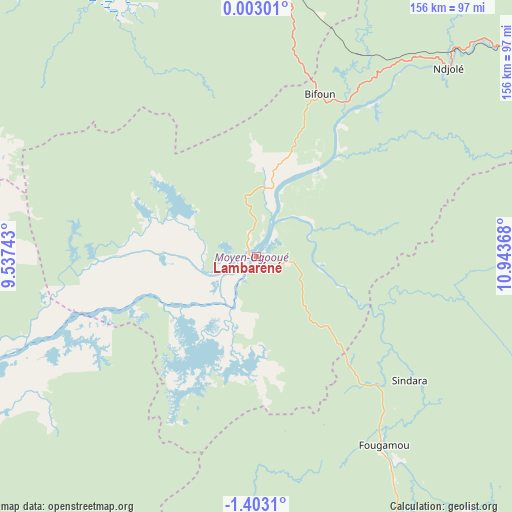
Lambaréné GPS coordinates[2]
0° 42' 0.36" South, 10° 14' 25.98" East
| Map corner | latitude | longitude |
|---|---|---|
| Upper-left | 0.00301°, | 9.53743° |
| Center: | -0.7001°, | 10.24055° |
| Lower-right: | -1.4031°, | 10.94368° |
| Map W x H: | 156.3×156.3 km | = 97.1×97.1mi |
| max Lat: | 2.07597° ⇑38.5% North |
| Lambaréné: | -0.7001° |
| min Lat: | ⇓61.5% South -3.43198° |
| min Long | Lambaréné | max Long |
| 8.78151° | 10.24055° | 14.25905° |
| W 23.1%⇐ | ⇒76.9% E |
Elevation
Elevation of Lambaréné is 26 m = 85 ft, and this is 231 m = 758 ft below average elevation for this country.
| Max E: |
667 m = 2188 ft | 76.9% |
| Avg. | 257 m = 843 ft | |
| Lambaréné | 26 m = 85 ft | |
Min E: |
4 m = 13 ft | 23.1% |
See also: Gabon elevation on elevation.city.
Geographical zone
Lambaréné is located in South Torrid zone (between Equator and Tropic of Capricorn). Distance of Equator is 77.8 km =48.3 mi to North.| Distance of | km | miles | from Lambaréné |
|---|---|---|---|
| Equator | 77.8 | 48.3 | to North |
| Tropic Capricorn | 2528.1 | 1570.9 | to South |
| Antarctic Circle | 7323.3 | 4550.5 | to South |
| South Pole | 9929.2 | 6169.7 | to South |


Nearby cities:
15 places around Lambaréné: (largest is in red/bold)
• Booué
200.5 km =124.6 mi,  70°
70°
• Cocobeach
202.7 km =126 mi,  338°
338°
• Fougamou
68.8 km =42.8 mi,  146°
146°
• Gamba
218.5 km =135.8 mi,  187°
187°
• Koulamoutou
251.9 km =156.5 mi,  101°
101°
• Libreville
149.7 km =93 mi,  324°
324°
• Mbigou
228.2 km =141.8 mi,  125°
125°
• Mimongo
183.1 km =113.8 mi,  123°
123°
• Mitzic
219.8 km =136.6 mi,  41°
41°
• Mouila
158.4 km =98.4 mi, 145°
• Ndendé
226.2 km =140.6 mi, 146°
• Ndjolé
82.3 km =51.1 mi,  45°
45°
• Ntoum
132.5 km =82.3 mi, 336°
• Omboué
145.9 km =90.7 mi,  228°
228°
• Port-Gentil
162.2 km =100.8 mi,  269°
269°
Sources, notices
• [Note1] Compared only with cities in Gabon existing in our database
• [Src1] Map data: © OpenStreetMap contributors (CC-BY-SA)
• [Src2] Other city data from geonames.org with taken over terms of usage.
• [Src3] Geographical zone / Annual Mean Temperature by Robert A. Rohde @ Wikipedia
