Omboué geodata
Omboué (Ogooué-Maritime) is a populated place; located in Gabon in Africa/Libreville (GMT+1) time zone. With population of 1,667 people, there are 25 cities with bigger population in this country. Compared to other cities in Gabon, 65.4% of cities are located further ↑North; 96.2% of cities are located further →East and 96.2% of cities have higher elevation than Omboué. Note1


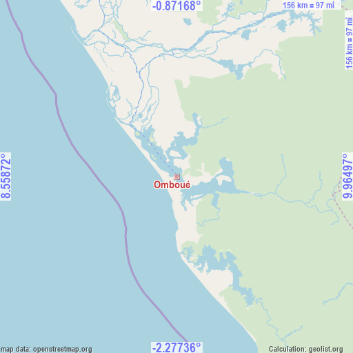
Omboué GPS coordinates[2]
1° 34' 28.704" South, 9° 15' 42.624" East
| Map corner | latitude | longitude |
|---|---|---|
| Upper-left | -0.87168°, | 8.55872° |
| Center: | -1.57464°, | 9.26184° |
| Lower-right: | -2.27736°, | 9.96497° |
| Map W x H: | 156.3×156.3 km | = 97.1×97.1mi |
| max Lat: | 2.07597° ⇑65.4% North |
| Omboué: | -1.57464° |
| min Lat: | ⇓34.6% South -3.43198° |
| min Long | Omboué | max Long |
| 8.78151° | 9.26184° | 14.25905° |
| W 3.8%⇐ | ⇒96.2% E |
Elevation
Elevation of Omboué is 8 m = 26 ft, and this is 249 m = 817 ft below average elevation for this country.
| Max E: |
667 m = 2188 ft | 96.2% |
| Avg. | 257 m = 843 ft | |
| Omboué | 8 m = 26 ft | |
Min E: |
4 m = 13 ft | 3.8% |
See also: Gabon elevation on elevation.city.
Geographical zone
Omboué is located in South Torrid zone (between Equator and Tropic of Capricorn). Distance of Equator is 175.1 km =108.8 mi to North.| Distance of | km | miles | from Omboué |
|---|---|---|---|
| Equator | 175.1 | 108.8 | to North |
| Tropic Capricorn | 2430.8 | 1510.4 | to South |
| Antarctic Circle | 7226.1 | 4490.1 | to South |
| South Pole | 9832 | 6109.3 | to South |


Nearby cities:
15 places around Omboué: (largest is in red/bold)
• Booué
340.2 km =211.4 mi,  61°
61°
• Cocobeach
288.5 km =179.3 mi,  7°
7°
• Fougamou
152.3 km =94.6 mi,  74°
74°
• Gamba
145 km =90.1 mi,  145°
145°
• Lambaréné
145.9 km =90.7 mi,  48°
48°
• Libreville
219.8 km =136.6 mi, 5°
• Mayumba
258.1 km =160.4 mi,  143°
143°
• Mbigou
296.1 km =184 mi,  97°
97°
• Mimongo
260.7 km =162 mi,  91°
91°
• Mouila
202.1 km =125.6 mi, 99°
• Ndendé
250.4 km =155.6 mi,  111°
111°
• Ndjolé
228.1 km =141.7 mi, 47°
• Ntoum
225.4 km =140.1 mi, 14°
• Port-Gentil
109.1 km =67.8 mi,  330°
330°
• Tchibanga
243.6 km =151.4 mi,  128°
128°
Sources, notices
• [Note1] Compared only with cities in Gabon existing in our database
• [Src1] Map data: © OpenStreetMap contributors (CC-BY-SA)
• [Src2] Other city data from geonames.org with taken over terms of usage.
• [Src3] Geographical zone / Annual Mean Temperature by Robert A. Rohde @ Wikipedia
