Mouila geodata
Mouila (Ngouni) is a seat of a first-order administrative division; located in Gabon in Africa/Libreville (GMT+1) time zone. With population of 22,469 people, there are 5 cities with bigger population in this country. Compared to other cities in Gabon, 80.8% of cities are located further ↑North; 57.7% of cities are located further →East and 61.5% of cities have higher elevation than Mouila. Note1


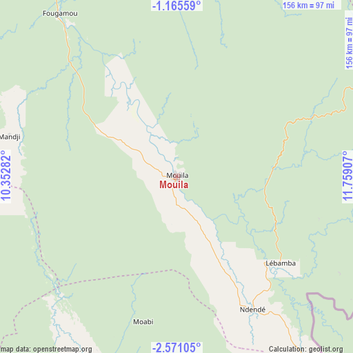
Mouila GPS coordinates[2]
1° 52' 6.456" South, 11° 3' 21.384" East
| Map corner | latitude | longitude |
|---|---|---|
| Upper-left | -1.16559°, | 10.35282° |
| Center: | -1.86846°, | 11.05594° |
| Lower-right: | -2.57105°, | 11.75907° |
| Map W x H: | 156.3×156.3 km | = 97.1×97.1mi |
| max Lat: | 2.07597° ⇑80.8% North |
| Mouila: | -1.86846° |
| min Lat: | ⇓19.2% South -3.43198° |
| min Long | Mouila | max Long |
| 8.78151° | 11.05594° | 14.25905° |
| W 42.3%⇐ | ⇒57.7% E |
Elevation
Elevation of Mouila is 92 m = 302 ft, and this is 165 m = 541 ft below average elevation for this country.
| Max E: |
667 m = 2188 ft | 61.5% |
| Avg. | 257 m = 843 ft | |
| Mouila | 92 m = 302 ft | |
Min E: |
4 m = 13 ft | 38.5% |
See also: Gabon elevation on elevation.city.
Geographical zone
Mouila is located in South Torrid zone (between Equator and Tropic of Capricorn). Distance of Equator is 207.8 km =129.1 mi to North.| Distance of | km | miles | from Mouila |
|---|---|---|---|
| Equator | 207.8 | 129.1 | to North |
| Tropic Capricorn | 2398.2 | 1490.2 | to South |
| Antarctic Circle | 7193.4 | 4469.8 | to South |
| South Pole | 9799.3 | 6089 | to South |


Nearby cities:
15 places around Mouila: (largest is in red/bold)
• Booué
220.5 km =137 mi,  26°
26°
• Fougamou
89.6 km =55.7 mi,  324°
324°
• Gamba
146 km =90.7 mi,  233°
233°
• Koulamoutou
176.4 km =109.6 mi,  62°
62°
• Lambaréné
158.4 km =98.4 mi,  325°
325°
• Lastoursville
217.7 km =135.3 mi, 57°
• Mayumba
179.4 km =111.5 mi,  194°
194°
• Mbigou
94.5 km =58.7 mi,  92°
92°
• Mimongo
67.2 km =41.8 mi,  65°
65°
• Moanda
240.5 km =149.4 mi,  81°
81°
• Mounana
239.2 km =148.6 mi, 77°
• Ndendé
68 km =42.3 mi,  150°
150°
• Ndjolé
190.7 km =118.5 mi,  350°
350°
• Omboué
202.1 km =125.6 mi,  279°
279°
• Tchibanga
118.7 km =73.8 mi,  183°
183°
Sources, notices
• [Note1] Compared only with cities in Gabon existing in our database
• [Src1] Map data: © OpenStreetMap contributors (CC-BY-SA)
• [Src2] Other city data from geonames.org with taken over terms of usage.
• [Src3] Geographical zone / Annual Mean Temperature by Robert A. Rohde @ Wikipedia
