Ndendé geodata
Ndendé (Ngouni) is a populated place; located in Gabon in Africa/Libreville (GMT+1) time zone. With population of 6,200 people, there are 16 cities with bigger population in this country. Compared to other cities in Gabon, 88.5% of cities are located further ↑North; 53.8% of cities are located further →East and 53.8% of cities have higher elevation than Ndendé. Note1


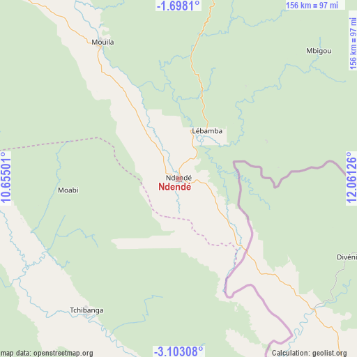
Ndendé GPS coordinates[2]
2° 24' 2.772" South, 11° 21' 29.268" East
| Map corner | latitude | longitude |
|---|---|---|
| Upper-left | -1.6981°, | 10.65501° |
| Center: | -2.40077°, | 11.35813° |
| Lower-right: | -3.10308°, | 12.06126° |
| Map W x H: | 156.2×156.2 km | = 97.1×97.1mi |
| max Lat: | 2.07597° ⇑88.5% North |
| Ndendé: | -2.40077° |
| min Lat: | ⇓11.5% South -3.43198° |
| min Long | Ndendé | max Long |
| 8.78151° | 11.35813° | 14.25905° |
| W 46.2%⇐ | ⇒53.8% E |
Elevation
Elevation of Ndendé is 130 m = 427 ft, and this is 127 m = 417 ft below average elevation for this country.
| Max E: |
667 m = 2188 ft | 53.8% |
| Avg. | 257 m = 843 ft | |
| Ndendé | 130 m = 427 ft | |
Min E: |
4 m = 13 ft | 46.2% |
See also: Gabon elevation on elevation.city.
Geographical zone
Ndendé is located in South Torrid zone (between Equator and Tropic of Capricorn). Distance of Equator is 266.9 km =165.8 mi to North.| Distance of | km | miles | from Ndendé |
|---|---|---|---|
| Equator | 266.9 | 165.8 | to North |
| Tropic Capricorn | 2339 | 1453.4 | to South |
| Antarctic Circle | 7134.2 | 4433 | to South |
| South Pole | 9740.1 | 6052.2 | to South |


Nearby cities:
15 places around Ndendé: (largest is in red/bold)
• Fougamou
157.4 km =97.8 mi,  326°
326°
• Franceville
261.6 km =162.6 mi,  70°
70°
• Gamba
153.4 km =95.3 mi,  259°
259°
• Koulamoutou
186.7 km =116 mi,  41°
41°
• Lambaréné
226.2 km =140.6 mi, 326°
• Lastoursville
231.3 km =143.7 mi, 40°
• Mayumba
138.7 km =86.2 mi,  214°
214°
• Mbigou
82.5 km =51.3 mi,  47°
47°
• Mimongo
91.2 km =56.7 mi,  17°
17°
• Moanda
224.6 km =139.6 mi, 65°
• Mouila
68 km =42.3 mi, 330°
• Mounana
228.5 km =142 mi,  61°
61°
• Ndjolé
255.8 km =158.9 mi,  345°
345°
• Omboué
250.4 km =155.6 mi,  291°
291°
• Tchibanga
72.5 km =45 mi,  215°
215°
Sources, notices
• [Note1] Compared only with cities in Gabon existing in our database
• [Src1] Map data: © OpenStreetMap contributors (CC-BY-SA)
• [Src2] Other city data from geonames.org with taken over terms of usage.
• [Src3] Geographical zone / Annual Mean Temperature by Robert A. Rohde @ Wikipedia
