Mumford geodata
Mumford (Central) is a populated place; located in Ghana in Africa/Accra (GMT+0) time zone. With population of 13,983 people, there are 61 cities with bigger population in this country. Compared to other cities in Ghana, 90.3% of cities are located further ↑North; 55.6% of cities are located further ←West and 79.2% of cities have higher elevation than Mumford. Note1


Mumford GPS coordinates[2]
5° 15' 42.336" North, 0° 45' 32.292" West
| Map corner | latitude | longitude |
|---|---|---|
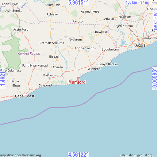
| Upper-left | 5.96151°, | -1.4621° |
| Center: | 5.26176°, | -0.75897° |
| Lower-right: | 4.56122°, | -0.05585° |
| Map W x H: | 155.7×155.7 km | = 96.7×96.7mi |
| max Lat: | 11.0616° ⇑90.3% North |
| Mumford: | 5.26176° |
| min Lat: | ⇓9.7% South 4.86641° |
| min Long | Mumford | max Long |
| -2.78516° | -0.75897° | 1.19012° |
| W 55.6%⇐ | ⇒44.4% E |
Elevation
Elevation of Mumford is 33 m = 108 ft, and this is 137.2 m = 450 ft below average elevation for this country.
| Max E: |
477 m = 1565 ft | 79.2% |
| Avg. | 170.2 m = 558 ft | |
| Mumford | 33 m = 108 ft | |
Min E: |
0 m = 0 ft | 20.8% |
See also: Ghana elevation on elevation.city.
Geographical zone
Mumford is located in North Torrid zone (between Equator and Tropic of Cancer). Distance of Equator is 585.1 km =363.6 mi to South.| Distance of | km | miles | from Mumford |
|---|---|---|---|
| North Pole | 9422 | 5854.6 | to North |
| Arctic Circle | 6816.1 | 4235.3 | to North |
| Tropic Cancer | 2020.9 | 1255.7 | to North |
| Equator | 585.1 | 363.6 | to South |


Nearby cities:
15 places around Mumford: (largest is in red/bold)
• Accra
70.3 km =43.7 mi,  62°
62°
• Akim Swedru
75.8 km =47.1 mi,  337°
337°
• Apam
3.5 km =2.2 mi,  43°
43°
• Asamankese
67.4 km =41.9 mi,  9°
9°
• Atsiaman
68 km =42.3 mi, 44°
• Cape Coast
56.7 km =35.2 mi,  252°
252°
• Dome
72.2 km =44.9 mi,  53°
53°
• Elmina
68.4 km =42.5 mi, 253°
• Foso
76.1 km =47.3 mi,  309°
309°
• Gbawe
60.8 km =37.8 mi, 54°
• Kasoa
48.5 km =30.1 mi, 51°
• Nsawam
75.8 km =47.1 mi, 36°
• Saltpond
33.9 km =21.1 mi,  260°
260°
• Swedru
31.3 km =19.4 mi, 12°
• Winneba
18 km =11.2 mi, 56°
Sources, notices
• [Note1] Compared only with cities in Ghana existing in our database
• [Src1] Map data: © OpenStreetMap contributors (CC-BY-SA)
• [Src2] Other city data from geonames.org with taken over terms of usage.
• [Src3] Geographical zone / Annual Mean Temperature by Robert A. Rohde @ Wikipedia
