Saltpond geodata
Saltpond (Central) is a populated place; located in Ghana in Africa/Accra (GMT+0) time zone. With population of 24,689 people, there are 50 cities with bigger population in this country. Compared to other cities in Ghana, 91.7% of cities are located further ↑North; 55.6% of cities are located further →East and 90.3% of cities have higher elevation than Saltpond. Note1


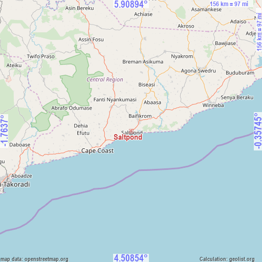
Saltpond GPS coordinates[2]
5° 12' 32.868" North, 1° 3' 38.088" West
| Map corner | latitude | longitude |
|---|---|---|
| Upper-left | 5.90894°, | -1.7637° |
| Center: | 5.20913°, | -1.06058° |
| Lower-right: | 4.50854°, | -0.35745° |
| Map W x H: | 155.7×155.7 km | = 96.7×96.7mi |
| max Lat: | 11.0616° ⇑91.7% North |
| Saltpond: | 5.20913° |
| min Lat: | ⇓8.3% South 4.86641° |
| min Long | Saltpond | max Long |
| -2.78516° | -1.06058° | 1.19012° |
| W 44.4%⇐ | ⇒55.6% E |
Elevation
Elevation of Saltpond is 14 m = 46 ft, and this is 156.2 m = 512 ft below average elevation for this country.
| Max E: |
477 m = 1565 ft | 90.3% |
| Avg. | 170.2 m = 558 ft | |
| Saltpond | 14 m = 46 ft | |
Min E: |
0 m = 0 ft | 9.7% |
See also: Ghana elevation on elevation.city.
Geographical zone
Saltpond is located in North Torrid zone (between Equator and Tropic of Cancer). Distance of Equator is 579.2 km =359.9 mi to South.| Distance of | km | miles | from Saltpond |
|---|---|---|---|
| North Pole | 9427.9 | 5858.2 | to North |
| Arctic Circle | 6822 | 4239 | to North |
| Tropic Cancer | 2026.7 | 1259.3 | to North |
| Equator | 579.2 | 359.9 | to South |


Nearby cities:
15 places around Saltpond: (largest is in red/bold)
• Akim Oda
80.2 km =49.8 mi,  5°
5°
• Akim Swedru
76.3 km =47.4 mi,  3°
3°
• Apam
36.8 km =22.9 mi,  76°
76°
• Asamankese
84.7 km =52.6 mi,  31°
31°
• Cape Coast
23.6 km =14.7 mi,  240°
240°
• Elmina
35 km =21.7 mi,  246°
246°
• Foso
60.2 km =37.4 mi,  335°
335°
• Gbawe
92.6 km =57.5 mi,  63°
63°
• Kasoa
79.9 km =49.6 mi, 63°
• Mumford
33.9 km =21.1 mi, 80°
• Sekondi-Takoradi
83.4 km =51.8 mi, 247°
• Shama Junction
70.2 km =43.6 mi, 252°
• Swedru
54.1 km =33.6 mi,  47°
47°
• Takoradi
84.9 km =52.8 mi, 245°
• Winneba
50.9 km =31.6 mi,  71°
71°
Sources, notices
• [Note1] Compared only with cities in Ghana existing in our database
• [Src1] Map data: © OpenStreetMap contributors (CC-BY-SA)
• [Src2] Other city data from geonames.org with taken over terms of usage.
• [Src3] Geographical zone / Annual Mean Temperature by Robert A. Rohde @ Wikipedia
