Apam geodata
Apam (Central) is a populated place; located in Ghana in Africa/Accra (GMT+0) time zone. With population of 20,147 people, there are 54 cities with bigger population in this country. Compared to other cities in Ghana, 88.9% of cities are located further ↑North; 56.9% of cities are located further ←West and 94.4% of cities have higher elevation than Apam. Note1


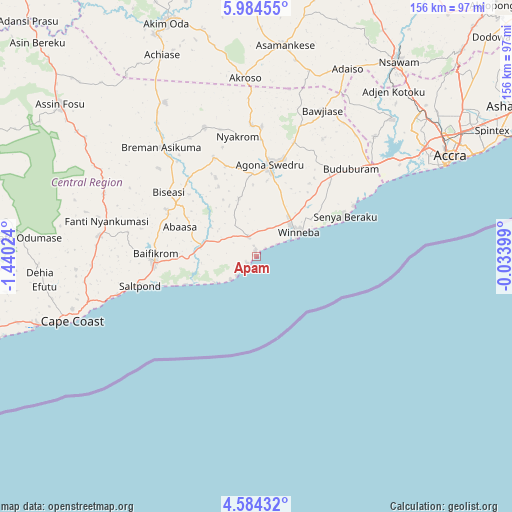
Apam GPS coordinates[2]
5° 17' 5.388" North, 0° 44' 13.596" West
| Map corner | latitude | longitude |
|---|---|---|
| Upper-left | 5.98455°, | -1.44024° |
| Center: | 5.28483°, | -0.73711° |
| Lower-right: | 4.58432°, | -0.03399° |
| Map W x H: | 155.7×155.7 km | = 96.7×96.7mi |
| max Lat: | 11.0616° ⇑88.9% North |
| Apam: | 5.28483° |
| min Lat: | ⇓11.1% South 4.86641° |
| min Long | Apam | max Long |
| -2.78516° | -0.73711° | 1.19012° |
| W 56.9%⇐ | ⇒43.1% E |
Elevation
Elevation of Apam is 12 m = 39 ft, and this is 158.2 m = 519 ft below average elevation for this country.
| Max E: |
477 m = 1565 ft | 94.4% |
| Avg. | 170.2 m = 558 ft | |
| Apam | 12 m = 39 ft | |
Min E: |
0 m = 0 ft | 5.6% |
See also: Ghana elevation on elevation.city.
Geographical zone
Apam is located in North Torrid zone (between Equator and Tropic of Cancer). Distance of Equator is 587.6 km =365.1 mi to South.| Distance of | km | miles | from Apam |
|---|---|---|---|
| North Pole | 9419.4 | 5852.9 | to North |
| Arctic Circle | 6813.6 | 4233.8 | to North |
| Tropic Cancer | 2018.3 | 1254.1 | to North |
| Equator | 587.6 | 365.1 | to South |


Nearby cities:
15 places around Apam: (largest is in red/bold)
• Accra
67 km =41.6 mi,  63°
63°
• Akim Swedru
74.4 km =46.2 mi,  335°
335°
• Asamankese
64.5 km =40.1 mi,  7°
7°
• Atsiaman
64.5 km =40.1 mi,  44°
44°
• Cape Coast
59.8 km =37.2 mi,  250°
250°
• Dome
68.7 km =42.7 mi,  53°
53°
• Elmina
71.5 km =44.4 mi, 251°
• Gbawe
57.3 km =35.6 mi, 55°
• Kasoa
45 km =28 mi, 51°
• Medina Estates
76.4 km =47.5 mi, 56°
• Mumford
3.5 km =2.2 mi,  223°
223°
• Nsawam
72.3 km =44.9 mi, 36°
• Saltpond
36.8 km =22.9 mi,  256°
256°
• Swedru
28.4 km =17.6 mi, 8°
• Winneba
14.6 km =9.1 mi, 59°
Sources, notices
• [Note1] Compared only with cities in Ghana existing in our database
• [Src1] Map data: © OpenStreetMap contributors (CC-BY-SA)
• [Src2] Other city data from geonames.org with taken over terms of usage.
• [Src3] Geographical zone / Annual Mean Temperature by Robert A. Rohde @ Wikipedia
