Tafo geodata
Tafo (Ashanti) is a populated place; located in Ghana in Africa/Accra (GMT+0) time zone. With population of 50,457 people, there are 25 cities with bigger population in this country. Compared to other cities in Ghana, 66.7% of cities are located further ↓South; 70.8% of cities are located further →East and 79.2% of cities have lower elevation than Tafo. Note1


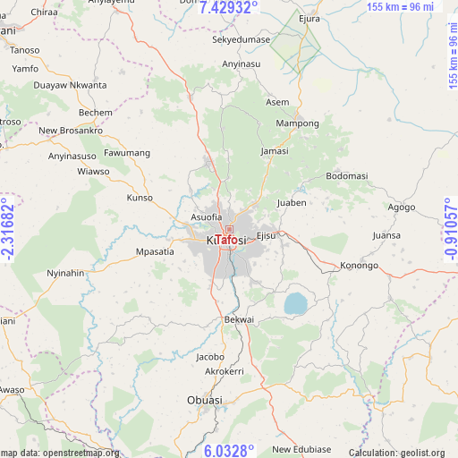
Tafo GPS coordinates[2]
6° 43' 53.616" North, 1° 36' 49.32" West
| Map corner | latitude | longitude |
|---|---|---|
| Upper-left | 7.42932°, | -2.31682° |
| Center: | 6.73156°, | -1.6137° |
| Lower-right: | 6.0328°, | -0.91057° |
| Map W x H: | 155.3×155.3 km | = 96.5×96.5mi |
| max Lat: | 11.0616° ⇑33.3% North |
| Tafo: | 6.73156° |
| min Lat: | ⇓66.7% South 4.86641° |
| min Long | Tafo | max Long |
| -2.78516° | -1.6137° | 1.19012° |
| W 29.2%⇐ | ⇒70.8% E |
Elevation
Elevation of Tafo is 291 m = 955 ft, and this is 120.8 m = 396 ft above average elevation for this country.
| Max E: |
477 m = 1565 ft | 20.8% |
| Tafo | 291 m 955 ft | |
| Avg. | 170.2 m = 558 ft | |
Min E: |
0 m = 0 ft | 79.2% |
See also: Tafo elevation on elevation.city.
Geographical zone
Tafo is located in North Torrid zone (between Equator and Tropic of Cancer). Distance of Equator is 748.5 km =465.1 mi to South.| Distance of | km | miles | from Tafo |
|---|---|---|---|
| North Pole | 9258.6 | 5753 | to North |
| Arctic Circle | 6652.7 | 4133.8 | to North |
| Tropic Cancer | 1857.4 | 1154.1 | to North |
| Equator | 748.5 | 465.1 | to South |


Nearby cities:
15 places around Tafo: (largest is in red/bold)
• Agogo
59.2 km =36.8 mi,  82°
82°
• Bechem
60.4 km =37.5 mi,  311°
311°
• Bekwai
31.3 km =19.4 mi,  172°
172°
• Bibiani
83.5 km =51.9 mi,  249°
249°
• Duayaw-Nkwanta
72.8 km =45.2 mi, 312°
• Dunkwa
87.7 km =54.5 mi,  191°
191°
• Ejura
78.1 km =48.5 mi,  21°
21°
• Konongo
45.7 km =28.4 mi,  106°
106°
• Kumasi
4.9 km =3 mi, 193°
• Mampong
43.7 km =27.2 mi,  32°
32°
• Mamponteng
7 km =4.3 mi,  88°
88°
• Mpraeso
98.3 km =61.1 mi,  99°
99°
• Obuase
59.2 km =36.8 mi, 185°
• Odumase Krobo
90.7 km =56.4 mi, 104°
• Techiman
101.3 km =62.9 mi,  339°
339°
Sources, notices
• [Note1] Compared only with cities in Ghana existing in our database
• [Src1] Map data: © OpenStreetMap contributors (CC-BY-SA)
• [Src2] Other city data from geonames.org with taken over terms of usage.
• [Src3] Geographical zone / Annual Mean Temperature by Robert A. Rohde @ Wikipedia
