Obuase geodata
Obuase (Ashanti) is a populated place; located in Ghana in Africa/Accra (GMT+0) time zone. With population of 137,856 people, there are 9 cities with bigger population in this country. Compared to other cities in Ghana, 54.2% of cities are located further ↓South; 75% of cities are located further →East and 72.2% of cities have lower elevation than Obuase. Note1


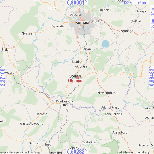
Obuase GPS coordinates[2]
6° 12' 8.208" North, 1° 40' 4.656" West
| Map corner | latitude | longitude |
|---|---|---|
| Upper-left | 6.90081°, | -2.37108° |
| Center: | 6.20228°, | -1.66796° |
| Lower-right: | 5.50282°, | -0.96483° |
| Map W x H: | 155.4×155.4 km | = 96.6×96.6mi |
| max Lat: | 11.0616° ⇑45.8% North |
| Obuase: | 6.20228° |
| min Lat: | ⇓54.2% South 4.86641° |
| min Long | Obuase | max Long |
| -2.78516° | -1.66796° | 1.19012° |
| W 25%⇐ | ⇒75% E |
Elevation
Elevation of Obuase is 233 m = 764 ft, and this is 62.8 m = 206 ft above average elevation for this country.
| Max E: |
477 m = 1565 ft | 27.8% |
| Obuase | 233 m 764 ft | |
| Avg. | 170.2 m = 558 ft | |
Min E: |
0 m = 0 ft | 72.2% |
See also: Obuase elevation on elevation.city.
Geographical zone
Obuase is located in North Torrid zone (between Equator and Tropic of Cancer). Distance of Equator is 689.6 km =428.5 mi to South.| Distance of | km | miles | from Obuase |
|---|---|---|---|
| North Pole | 9317.4 | 5789.6 | to North |
| Arctic Circle | 6711.5 | 4170.3 | to North |
| Tropic Cancer | 1916.3 | 1190.7 | to North |
| Equator | 689.6 | 428.5 | to South |


Nearby cities:
15 places around Obuase: (largest is in red/bold)
• Aboso
98.6 km =61.3 mi,  198°
198°
• Agogo
92.8 km =57.7 mi,  44°
44°
• Akim Oda
81.4 km =50.6 mi,  112°
112°
• Akim Swedru
79.8 km =49.6 mi,  115°
115°
• Akwatia
96.7 km =60.1 mi,  100°
100°
• Bekwai
29.5 km =18.3 mi,  19°
19°
• Bibiani
77.6 km =48.2 mi,  291°
291°
• Dunkwa
29.6 km =18.4 mi, 204°
• Foso
69.9 km =43.4 mi,  142°
142°
• Konongo
67.9 km =42.2 mi,  47°
47°
• Kumasi
54.3 km =33.7 mi,  5°
5°
• Mampong
100.1 km =62.2 mi, 17°
• Mamponteng
60.5 km =37.6 mi, 12°
• Tafo
59.2 km =36.8 mi, 5°
• Wassa-Akropong
65.1 km =40.5 mi,  224°
224°
Sources, notices
• [Note1] Compared only with cities in Ghana existing in our database
• [Src1] Map data: © OpenStreetMap contributors (CC-BY-SA)
• [Src2] Other city data from geonames.org with taken over terms of usage.
• [Src3] Geographical zone / Annual Mean Temperature by Robert A. Rohde @ Wikipedia
