Duayaw-Nkwanta geodata
Duayaw-Nkwanta (Brong-Ahafo) is a populated place; located in Ghana in Africa/Accra (GMT+0) time zone. With population of 17,000 people, there are 59 cities with bigger population in this country. Compared to other cities in Ghana, 76.4% of cities are located further ↓South; 88.9% of cities are located further →East and 83.3% of cities have lower elevation than Duayaw-Nkwanta. Note1


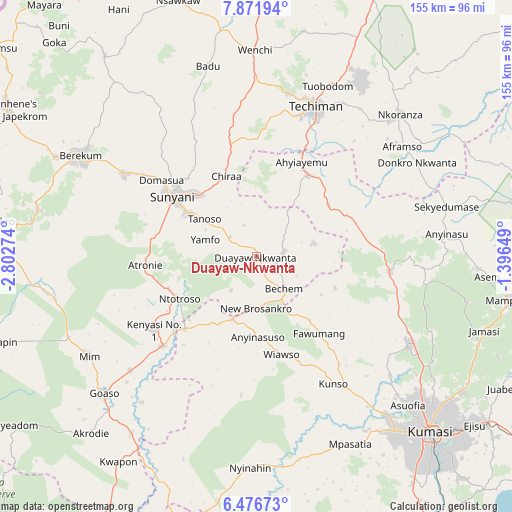
Duayaw-Nkwanta GPS coordinates[2]
7° 10' 29.532" North, 2° 5' 58.596" West
| Map corner | latitude | longitude |
|---|---|---|
| Upper-left | 7.87194°, | -2.80274° |
| Center: | 7.17487°, | -2.09961° |
| Lower-right: | 6.47673°, | -1.39649° |
| Map W x H: | 155.1×155.1 km | = 96.4×96.4mi |
| max Lat: | 11.0616° ⇑23.6% North |
| Duayaw-Nkwanta: | 7.17487° |
| min Lat: | ⇓76.4% South 4.86641° |
| min Long | Duayaw-Nkwanta | max Long |
| -2.78516° | -2.09961° | 1.19012° |
| W 11.1%⇐ | ⇒88.9% E |
Elevation
Elevation of Duayaw-Nkwanta is 304 m = 997 ft, and this is 133.8 m = 439 ft above average elevation for this country.
| Max E: |
477 m = 1565 ft | 16.7% |
| Duayaw-Nkwanta | 304 m 997 ft | |
| Avg. | 170.2 m = 558 ft | |
Min E: |
0 m = 0 ft | 83.3% |
See also: Ghana elevation on elevation.city.
Geographical zone
Duayaw-Nkwanta is located in North Torrid zone (between Equator and Tropic of Cancer). Distance of Equator is 797.8 km =495.7 mi to South.| Distance of | km | miles | from Duayaw-Nkwanta |
|---|---|---|---|
| North Pole | 9209.3 | 5722.4 | to North |
| Arctic Circle | 6603.4 | 4103.2 | to North |
| Tropic Cancer | 1808.1 | 1123.5 | to North |
| Equator | 797.8 | 495.7 | to South |


Nearby cities:
15 places around Duayaw-Nkwanta: (largest is in red/bold)
• Bechem
12.5 km =7.8 mi,  138°
138°
• Bekwai
98.8 km =61.4 mi, 144°
• Berekum
61.8 km =38.4 mi,  300°
300°
• Bibiani
82.7 km =51.4 mi,  197°
197°
• Ejura
85.3 km =53 mi,  74°
74°
• Japekrom
87.8 km =54.6 mi, 300°
• Kintampo
106.1 km =65.9 mi,  22°
22°
• Konongo
115.5 km =71.8 mi,  122°
122°
• Kumasi
75.3 km =46.8 mi, 135°
• Mampong
78.2 km =48.6 mi,  99°
99°
• Mamponteng
78 km =48.5 mi,  128°
128°
• Sunyani
31.1 km =19.3 mi,  306°
306°
• Tafo
72.8 km =45.2 mi, 132°
• Techiman
48.9 km =30.4 mi, 21°
• Wenchi
62.7 km =39 mi,  359°
359°
Sources, notices
• [Note1] Compared only with cities in Ghana existing in our database
• [Src1] Map data: © OpenStreetMap contributors (CC-BY-SA)
• [Src2] Other city data from geonames.org with taken over terms of usage.
• [Src3] Geographical zone / Annual Mean Temperature by Robert A. Rohde @ Wikipedia
