Dunkwa geodata
Dunkwa (Central) is a populated place; located in Ghana in Africa/Accra (GMT+0) time zone. With population of 33,379 people, there are 40 cities with bigger population in this country. Compared to other cities in Ghana, 55.6% of cities are located further ↑North; 80.6% of cities are located further →East and 59.7% of cities have higher elevation than Dunkwa. Note1


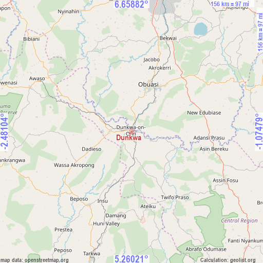
Dunkwa GPS coordinates[2]
5° 57' 35.856" North, 1° 46' 40.512" West
| Map corner | latitude | longitude |
|---|---|---|
| Upper-left | 6.65882°, | -2.48104° |
| Center: | 5.95996°, | -1.77792° |
| Lower-right: | 5.26021°, | -1.07479° |
| Map W x H: | 155.5×155.5 km | = 96.6×96.6mi |
| max Lat: | 11.0616° ⇑55.6% North |
| Dunkwa: | 5.95996° |
| min Lat: | ⇓44.4% South 4.86641° |
| min Long | Dunkwa | max Long |
| -2.78516° | -1.77792° | 1.19012° |
| W 19.4%⇐ | ⇒80.6% E |
Elevation
Elevation of Dunkwa is 118 m = 387 ft, and this is 52.2 m = 171 ft below average elevation for this country.
| Max E: |
477 m = 1565 ft | 59.7% |
| Avg. | 170.2 m = 558 ft | |
| Dunkwa | 118 m = 387 ft | |
Min E: |
0 m = 0 ft | 40.3% |
See also: Ghana elevation on elevation.city.
Geographical zone
Dunkwa is located in North Torrid zone (between Equator and Tropic of Cancer). Distance of Equator is 662.7 km =411.8 mi to South.| Distance of | km | miles | from Dunkwa |
|---|---|---|---|
| North Pole | 9344.4 | 5806.3 | to North |
| Arctic Circle | 6738.5 | 4187.1 | to North |
| Tropic Cancer | 1943.2 | 1207.4 | to North |
| Equator | 662.7 | 411.8 | to South |


Nearby cities:
15 places around Dunkwa: (largest is in red/bold)
• Aboso
69.3 km =43.1 mi,  195°
195°
• Akim Oda
87.7 km =54.5 mi,  92°
92°
• Akim Swedru
84.5 km =52.5 mi, 94°
• Bekwai
59 km =36.7 mi,  21°
21°
• Bibiani
82 km =51 mi,  313°
313°
• Foso
61.5 km =38.2 mi,  117°
117°
• Konongo
95.8 km =59.5 mi,  40°
40°
• Kumasi
82.8 km =51.4 mi,  11°
11°
• Mamponteng
89.6 km =55.7 mi, 16°
• Obuase
29.6 km =18.4 mi, 24°
• Prestea
71.1 km =44.2 mi,  214°
214°
• Shama Junction
105.5 km =65.6 mi,  173°
173°
• Tafo
87.7 km =54.5 mi, 11°
• Tarkwa
76.6 km =47.6 mi, 197°
• Wassa-Akropong
38.9 km =24.2 mi,  240°
240°
Sources, notices
• [Note1] Compared only with cities in Ghana existing in our database
• [Src1] Map data: © OpenStreetMap contributors (CC-BY-SA)
• [Src2] Other city data from geonames.org with taken over terms of usage.
• [Src3] Geographical zone / Annual Mean Temperature by Robert A. Rohde @ Wikipedia
