Techiman geodata
Techiman (Brong-Ahafo) is a populated place; located in Ghana in Africa/Accra (GMT+0) time zone. With population of 69,720 people, there are 18 cities with bigger population in this country. Compared to other cities in Ghana, 83.3% of cities are located further ↓South; 81.9% of cities are located further →East and 91.7% of cities have lower elevation than Techiman. Note1


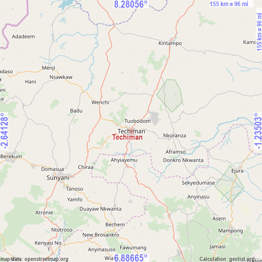
Techiman GPS coordinates[2]
7° 35' 3.012" North, 1° 56' 17.34" West
| Map corner | latitude | longitude |
|---|---|---|
| Upper-left | 8.28056°, | -2.64128° |
| Center: | 7.58417°, | -1.93815° |
| Lower-right: | 6.88665°, | -1.23503° |
| Map W x H: | 155×155 km | = 96.3×96.3mi |
| max Lat: | 11.0616° ⇑16.7% North |
| Techiman: | 7.58417° |
| min Lat: | ⇓83.3% South 4.86641° |
| min Long | Techiman | max Long |
| -2.78516° | -1.93815° | 1.19012° |
| W 18.1%⇐ | ⇒81.9% E |
Elevation
Elevation of Techiman is 390 m = 1280 ft, and this is 219.8 m = 721 ft above average elevation for this country.
| Max E: |
477 m = 1565 ft | 8.3% |
| Techiman | 390 m 1280 ft | |
| Avg. | 170.2 m = 558 ft | |
Min E: |
0 m = 0 ft | 91.7% |
See also: Techiman elevation on elevation.city.
Geographical zone
Techiman is located in North Torrid zone (between Equator and Tropic of Cancer). Distance of Equator is 843.3 km =524 mi to South.| Distance of | km | miles | from Techiman |
|---|---|---|---|
| North Pole | 9163.8 | 5694.1 | to North |
| Arctic Circle | 6557.9 | 4074.9 | to North |
| Tropic Cancer | 1762.6 | 1095.2 | to North |
| Equator | 843.3 | 524 | to South |


Nearby cities:
15 places around Techiman: (largest is in red/bold)
• Agogo
128.5 km =79.8 mi,  132°
132°
• Bechem
55.7 km =34.6 mi,  189°
189°
• Bekwai
132 km =82 mi,  162°
162°
• Berekum
72.7 km =45.2 mi,  258°
258°
• Bibiani
131.5 km =81.7 mi,  198°
198°
• Duayaw-Nkwanta
48.9 km =30.4 mi, 201°
• Ejura
67.9 km =42.2 mi,  108°
108°
• Japekrom
93.4 km =58 mi,  269°
269°
• Kintampo
57.3 km =35.6 mi,  23°
23°
• Kumasi
105.4 km =65.5 mi, 160°
• Mampong
83 km =51.6 mi, 134°
• Mamponteng
103.8 km =64.5 mi, 155°
• Sunyani
50.7 km =31.5 mi,  237°
237°
• Tafo
101.3 km =62.9 mi, 159°
• Wenchi
25.2 km =15.7 mi,  313°
313°
Sources, notices
• [Note1] Compared only with cities in Ghana existing in our database
• [Src1] Map data: © OpenStreetMap contributors (CC-BY-SA)
• [Src2] Other city data from geonames.org with taken over terms of usage.
• [Src3] Geographical zone / Annual Mean Temperature by Robert A. Rohde @ Wikipedia
