Bekwai geodata
Bekwai (Ashanti) is a populated place; located in Ghana in Africa/Accra (GMT+0) time zone. With population of 4,260 people, there are 69 cities with bigger population in this country. Compared to other cities in Ghana, 56.9% of cities are located further ↓South; 69.4% of cities are located further →East and 70.8% of cities have lower elevation than Bekwai. Note1


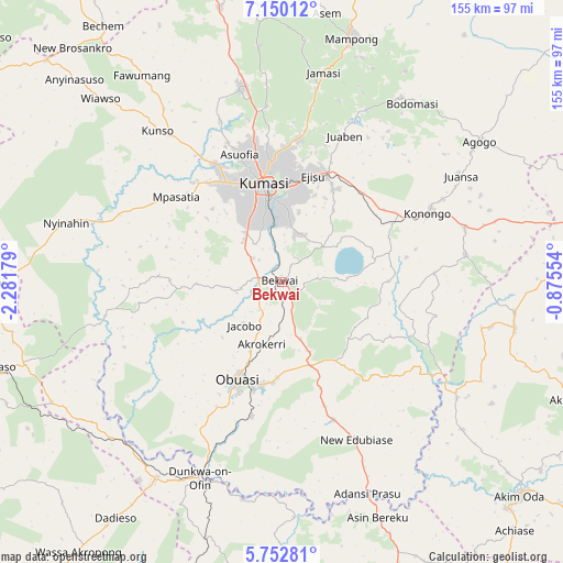
Bekwai GPS coordinates[2]
6° 27' 7.02" North, 1° 34' 43.176" West
| Map corner | latitude | longitude |
|---|---|---|
| Upper-left | 7.15012°, | -2.28179° |
| Center: | 6.45195°, | -1.57866° |
| Lower-right: | 5.75281°, | -0.87554° |
| Map W x H: | 155.4×155.4 km | = 96.6×96.6mi |
| max Lat: | 11.0616° ⇑43.1% North |
| Bekwai: | 6.45195° |
| min Lat: | ⇓56.9% South 4.86641° |
| min Long | Bekwai | max Long |
| -2.78516° | -1.57866° | 1.19012° |
| W 30.6%⇐ | ⇒69.4% E |
Elevation
Elevation of Bekwai is 231 m = 758 ft, and this is 60.8 m = 199 ft above average elevation for this country.
| Max E: |
477 m = 1565 ft | 29.2% |
| Bekwai | 231 m 758 ft | |
| Avg. | 170.2 m = 558 ft | |
Min E: |
0 m = 0 ft | 70.8% |
See also: Ghana elevation on elevation.city.
Geographical zone
Bekwai is located in North Torrid zone (between Equator and Tropic of Cancer). Distance of Equator is 717.4 km =445.8 mi to South.| Distance of | km | miles | from Bekwai |
|---|---|---|---|
| North Pole | 9289.7 | 5772.4 | to North |
| Arctic Circle | 6683.8 | 4153.1 | to North |
| Tropic Cancer | 1888.5 | 1173.5 | to North |
| Equator | 717.4 | 445.8 | to South |


Nearby cities:
15 places around Bekwai: (largest is in red/bold)
• Agogo
67.1 km =41.7 mi,  54°
54°
• Akim Oda
87.8 km =54.6 mi,  131°
131°
• Akim Swedru
87.8 km =54.6 mi, 134°
• Bechem
86.4 km =53.7 mi,  325°
325°
• Bibiani
81.8 km =50.8 mi,  270°
270°
• Dunkwa
59 km =36.7 mi,  201°
201°
• Foso
89.5 km =55.6 mi,  158°
158°
• Konongo
44 km =27.3 mi,  65°
65°
• Kumasi
26.8 km =16.7 mi,  349°
349°
• Mampong
70.7 km =43.9 mi,  16°
16°
• Mamponteng
31.4 km =19.5 mi,  5°
5°
• Obuase
29.5 km =18.3 mi, 199°
• Odumase Krobo
84.7 km =52.6 mi,  83°
83°
• Tafo
31.3 km =19.4 mi, 352°
• Wassa-Akropong
92.6 km =57.5 mi,  217°
217°
Sources, notices
• [Note1] Compared only with cities in Ghana existing in our database
• [Src1] Map data: © OpenStreetMap contributors (CC-BY-SA)
• [Src2] Other city data from geonames.org with taken over terms of usage.
• [Src3] Geographical zone / Annual Mean Temperature by Robert A. Rohde @ Wikipedia
