Bibiani geodata
Bibiani (Western) is a populated place; located in Ghana in Africa/Accra (GMT+0) time zone. With population of 19,076 people, there are 56 cities with bigger population in this country. Compared to other cities in Ghana, 58.3% of cities are located further ↓South; 94.4% of cities are located further →East and 66.7% of cities have lower elevation than Bibiani. Note1


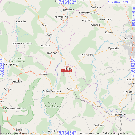
Bibiani GPS coordinates[2]
6° 27' 48.456" North, 2° 19' 9.768" West
| Map corner | latitude | longitude |
|---|---|---|
| Upper-left | 7.16162°, | -3.02251° |
| Center: | 6.46346°, | -2.31938° |
| Lower-right: | 5.76434°, | -1.61626° |
| Map W x H: | 155.4×155.4 km | = 96.6×96.6mi |
| max Lat: | 11.0616° ⇑41.7% North |
| Bibiani: | 6.46346° |
| min Lat: | ⇓58.3% South 4.86641° |
| min Long | Bibiani | max Long |
| -2.78516° | -2.31938° | 1.19012° |
| W 5.6%⇐ | ⇒94.4% E |
Elevation
Elevation of Bibiani is 223 m = 732 ft, and this is 52.8 m = 173 ft above average elevation for this country.
| Max E: |
477 m = 1565 ft | 33.3% |
| Bibiani | 223 m 732 ft | |
| Avg. | 170.2 m = 558 ft | |
Min E: |
0 m = 0 ft | 66.7% |
See also: Ghana elevation on elevation.city.
Geographical zone
Bibiani is located in North Torrid zone (between Equator and Tropic of Cancer). Distance of Equator is 718.7 km =446.6 mi to South.| Distance of | km | miles | from Bibiani |
|---|---|---|---|
| North Pole | 9288.4 | 5771.5 | to North |
| Arctic Circle | 6682.5 | 4152.3 | to North |
| Tropic Cancer | 1887.2 | 1172.7 | to North |
| Equator | 718.7 | 446.6 | to South |


Nearby cities:
15 places around Bibiani: (largest is in red/bold)
• Aboso
129.3 km =80.3 mi,  161°
161°
• Bechem
76.9 km =47.8 mi,  25°
25°
• Bekwai
81.8 km =50.8 mi,  90°
90°
• Berekum
113.9 km =70.8 mi,  345°
345°
• Duayaw-Nkwanta
82.7 km =51.4 mi,  17°
17°
• Dunkwa
82 km =51 mi,  133°
133°
• Konongo
123 km =76.4 mi,  82°
82°
• Kumasi
80.7 km =50.1 mi,  71°
71°
• Mampong
121.4 km =75.4 mi,  56°
56°
• Mamponteng
90.1 km =56 mi, 70°
• Obuase
77.6 km =48.2 mi,  111°
111°
• Prestea
116.1 km =72.1 mi,  170°
170°
• Sunyani
97.5 km =60.6 mi,  359°
359°
• Tafo
83.5 km =51.9 mi, 69°
• Wassa-Akropong
79.6 km =49.5 mi, 160°
Sources, notices
• [Note1] Compared only with cities in Ghana existing in our database
• [Src1] Map data: © OpenStreetMap contributors (CC-BY-SA)
• [Src2] Other city data from geonames.org with taken over terms of usage.
• [Src3] Geographical zone / Annual Mean Temperature by Robert A. Rohde @ Wikipedia
