Akim Oda geodata
Akim Oda (Eastern) is a populated place; located in Ghana in Africa/Accra (GMT+0) time zone. With population of 60,604 people, there are 21 cities with bigger population in this country. Compared to other cities in Ghana, 56.9% of cities are located further ↑North; 52.8% of cities are located further →East and 58.3% of cities have higher elevation than Akim Oda. Note1


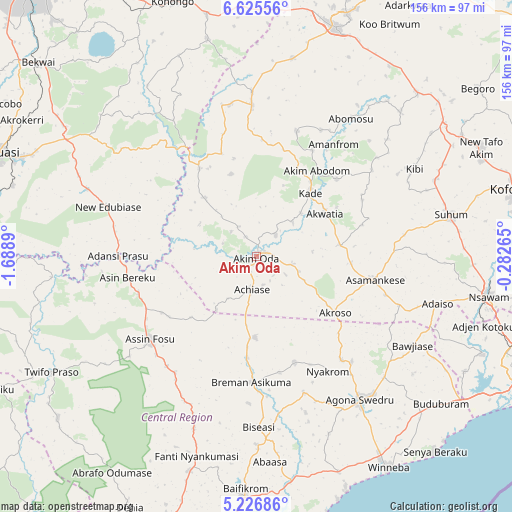
Akim Oda GPS coordinates[2]
5° 55' 35.94" North, 0° 59' 8.772" West
| Map corner | latitude | longitude |
|---|---|---|
| Upper-left | 6.62556°, | -1.6889° |
| Center: | 5.92665°, | -0.98577° |
| Lower-right: | 5.22686°, | -0.28265° |
| Map W x H: | 155.5×155.5 km | = 96.6×96.6mi |
| max Lat: | 11.0616° ⇑56.9% North |
| Akim Oda: | 5.92665° |
| min Lat: | ⇓43.1% South 4.86641° |
| min Long | Akim Oda | max Long |
| -2.78516° | -0.98577° | 1.19012° |
| W 47.2%⇐ | ⇒52.8% E |
Elevation
Elevation of Akim Oda is 132 m = 433 ft, and this is 38.2 m = 125 ft below average elevation for this country.
| Max E: |
477 m = 1565 ft | 58.3% |
| Avg. | 170.2 m = 558 ft | |
| Akim Oda | 132 m = 433 ft | |
Min E: |
0 m = 0 ft | 41.7% |
See also: Akim Oda elevation on elevation.city.
Geographical zone
Akim Oda is located in North Torrid zone (between Equator and Tropic of Cancer). Distance of Equator is 659 km =409.5 mi to South.| Distance of | km | miles | from Akim Oda |
|---|---|---|---|
| North Pole | 9348.1 | 5808.6 | to North |
| Arctic Circle | 6742.2 | 4189.4 | to North |
| Tropic Cancer | 1946.9 | 1209.7 | to North |
| Equator | 659 | 409.5 | to South |


Nearby cities:
15 places around Akim Oda: (largest is in red/bold)
• Akim Swedru
5 km =3.1 mi,  222°
222°
• Akwatia
23.3 km =14.5 mi,  57°
57°
• Apam
76.5 km =47.5 mi,  158°
158°
• Asamankese
36.4 km =22.6 mi,  101°
101°
• Atsiaman
77.1 km =47.9 mi,  109°
109°
• Foso
41.7 km =25.9 mi,  233°
233°
• Kasoa
76.6 km =47.6 mi,  124°
124°
• Kibi
54.6 km =33.9 mi, 60°
• Mpraeso
79.1 km =49.2 mi,  20°
20°
• Mumford
78.1 km =48.5 mi, 161°
• Nsawam
71.5 km =44.4 mi, 100°
• Odumase Krobo
70 km =43.5 mi, 15°
• Suhum
60.6 km =37.7 mi,  77°
77°
• Swedru
53.6 km =33.3 mi,  143°
143°
• Winneba
75.5 km =46.9 mi,  147°
147°
Sources, notices
• [Note1] Compared only with cities in Ghana existing in our database
• [Src1] Map data: © OpenStreetMap contributors (CC-BY-SA)
• [Src2] Other city data from geonames.org with taken over terms of usage.
• [Src3] Geographical zone / Annual Mean Temperature by Robert A. Rohde @ Wikipedia
