Foso geodata
Foso (Central) is a populated place; located in Ghana in Africa/Accra (GMT+0) time zone. With population of 20,078 people, there are 55 cities with bigger population in this country. Compared to other cities in Ghana, 68.1% of cities are located further ↑North; 62.5% of cities are located further →East and 52.8% of cities have higher elevation than Foso. Note1


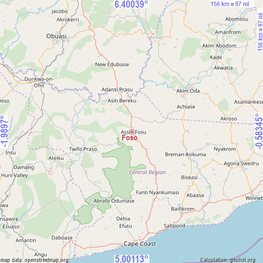
Foso GPS coordinates[2]
5° 42' 4.284" North, 1° 17' 11.652" West
| Map corner | latitude | longitude |
|---|---|---|
| Upper-left | 6.40039°, | -1.9897° |
| Center: | 5.70119°, | -1.28657° |
| Lower-right: | 5.00113°, | -0.58345° |
| Map W x H: | 155.6×155.6 km | = 96.7×96.7mi |
| max Lat: | 11.0616° ⇑68.1% North |
| Foso: | 5.70119° |
| min Lat: | ⇓31.9% South 4.86641° |
| min Long | Foso | max Long |
| -2.78516° | -1.28657° | 1.19012° |
| W 37.5%⇐ | ⇒62.5% E |
Elevation
Elevation of Foso is 148 m = 486 ft, and this is 22.2 m = 73 ft below average elevation for this country.
| Max E: |
477 m = 1565 ft | 52.8% |
| Avg. | 170.2 m = 558 ft | |
| Foso | 148 m = 486 ft | |
Min E: |
0 m = 0 ft | 47.2% |
See also: Ghana elevation on elevation.city.
Geographical zone
Foso is located in North Torrid zone (between Equator and Tropic of Cancer). Distance of Equator is 633.9 km =393.9 mi to South.| Distance of | km | miles | from Foso |
|---|---|---|---|
| North Pole | 9373.1 | 5824.2 | to North |
| Arctic Circle | 6767.3 | 4205 | to North |
| Tropic Cancer | 1972 | 1225.3 | to North |
| Equator | 633.9 | 393.9 | to South |


Nearby cities:
15 places around Foso: (largest is in red/bold)
• Aboso
82.5 km =51.3 mi,  242°
242°
• Akim Oda
41.7 km =25.9 mi,  53°
53°
• Akim Swedru
36.8 km =22.9 mi, 54°
• Akwatia
64.9 km =40.3 mi, 54°
• Apam
76.4 km =47.5 mi,  127°
127°
• Asamankese
71.2 km =44.2 mi,  75°
75°
• Cape Coast
66.4 km =41.3 mi,  176°
176°
• Dunkwa
61.5 km =38.2 mi,  297°
297°
• Elmina
68.9 km =42.8 mi,  185°
185°
• Mumford
76.1 km =47.3 mi, 129°
• Obuase
69.9 km =43.4 mi,  322°
322°
• Saltpond
60.2 km =37.4 mi,  155°
155°
• Shama Junction
86.7 km =53.9 mi,  208°
208°
• Swedru
67.4 km =41.9 mi,  105°
105°
• Winneba
83.1 km =51.6 mi,  117°
117°
Sources, notices
• [Note1] Compared only with cities in Ghana existing in our database
• [Src1] Map data: © OpenStreetMap contributors (CC-BY-SA)
• [Src2] Other city data from geonames.org with taken over terms of usage.
• [Src3] Geographical zone / Annual Mean Temperature by Robert A. Rohde @ Wikipedia
