Akwatia geodata
Akwatia (Eastern) is a populated place; located in Ghana in Africa/Accra (GMT+0) time zone. With population of 23,766 people, there are 52 cities with bigger population in this country. Compared to other cities in Ghana, 52.8% of cities are located further ↑North; 54.2% of cities are located further ←West and 56.9% of cities have higher elevation than Akwatia. Note1


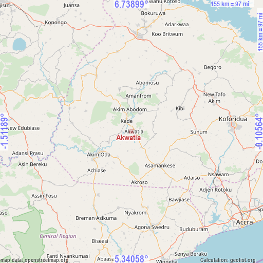
Akwatia GPS coordinates[2]
6° 2' 24.864" North, 0° 48' 31.536" West
| Map corner | latitude | longitude |
|---|---|---|
| Upper-left | 6.73899°, | -1.51189° |
| Center: | 6.04024°, | -0.80876° |
| Lower-right: | 5.34058°, | -0.10564° |
| Map W x H: | 155.5×155.5 km | = 96.6×96.6mi |
| max Lat: | 11.0616° ⇑52.8% North |
| Akwatia: | 6.04024° |
| min Lat: | ⇓47.2% South 4.86641° |
| min Long | Akwatia | max Long |
| -2.78516° | -0.80876° | 1.19012° |
| W 54.2%⇐ | ⇒45.8% E |
Elevation
Elevation of Akwatia is 138 m = 453 ft, and this is 32.2 m = 106 ft below average elevation for this country.
| Max E: |
477 m = 1565 ft | 56.9% |
| Avg. | 170.2 m = 558 ft | |
| Akwatia | 138 m = 453 ft | |
Min E: |
0 m = 0 ft | 43.1% |
See also: Ghana elevation on elevation.city.
Geographical zone
Akwatia is located in North Torrid zone (between Equator and Tropic of Cancer). Distance of Equator is 671.6 km =417.3 mi to South.| Distance of | km | miles | from Akwatia |
|---|---|---|---|
| North Pole | 9335.5 | 5800.8 | to North |
| Arctic Circle | 6729.6 | 4181.6 | to North |
| Tropic Cancer | 1934.3 | 1201.9 | to North |
| Equator | 671.6 | 417.3 | to South |


Nearby cities:
15 places around Akwatia: (largest is in red/bold)
• Aburi
73.3 km =45.5 mi,  106°
106°
• Akim Oda
23.3 km =14.5 mi,  237°
237°
• Akim Swedru
28.1 km =17.5 mi,  234°
234°
• Asamankese
25.7 km =16 mi,  141°
141°
• Atsiaman
65.4 km =40.6 mi,  125°
125°
• Begoro
61.3 km =38.1 mi,  51°
51°
• Foso
64.9 km =40.3 mi, 234°
• Kasoa
71 km =44.1 mi, 142°
• Kibi
31.4 km =19.5 mi,  63°
63°
• Koforidua
61.1 km =38 mi,  84°
84°
• Mpraeso
62 km =38.5 mi,  7°
7°
• Nsawam
56.9 km =35.4 mi,  116°
116°
• Odumase Krobo
54.8 km =34.1 mi,  359°
359°
• Suhum
39.7 km =24.7 mi,  89°
89°
• Swedru
57.2 km =35.5 mi,  167°
167°
Sources, notices
• [Note1] Compared only with cities in Ghana existing in our database
• [Src1] Map data: © OpenStreetMap contributors (CC-BY-SA)
• [Src2] Other city data from geonames.org with taken over terms of usage.
• [Src3] Geographical zone / Annual Mean Temperature by Robert A. Rohde @ Wikipedia
