Akim Swedru geodata
Akim Swedru (Eastern) is a seat of a second-order administrative division; located in Ghana in Africa/Accra (GMT+0) time zone. With population of 10,000 people, there are 64 cities with bigger population in this country. Compared to other cities in Ghana, 59.7% of cities are located further ↑North; 54.2% of cities are located further →East and 55.6% of cities have higher elevation than Akim Swedru. Note1


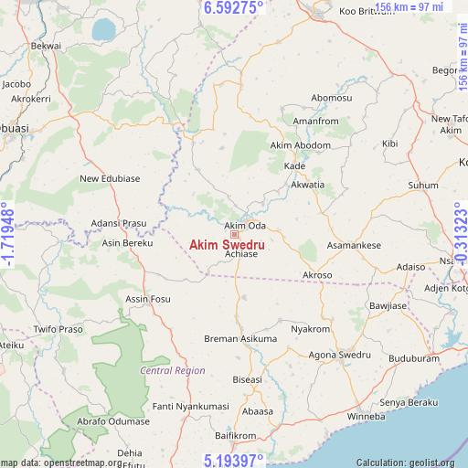
Akim Swedru GPS coordinates[2]
5° 53' 37.68" North, 1° 0' 58.896" West
| Map corner | latitude | longitude |
|---|---|---|
| Upper-left | 6.59275°, | -1.71948° |
| Center: | 5.8938°, | -1.01636° |
| Lower-right: | 5.19397°, | -0.31323° |
| Map W x H: | 155.5×155.5 km | = 96.6×96.6mi |
| max Lat: | 11.0616° ⇑59.7% North |
| Akim Swedru: | 5.8938° |
| min Lat: | ⇓40.3% South 4.86641° |
| min Long | Akim Swedru | max Long |
| -2.78516° | -1.01636° | 1.19012° |
| W 45.8%⇐ | ⇒54.2% E |
Elevation
Elevation of Akim Swedru is 140 m = 459 ft, and this is 30.2 m = 99 ft below average elevation for this country.
| Max E: |
477 m = 1565 ft | 55.6% |
| Avg. | 170.2 m = 558 ft | |
| Akim Swedru | 140 m = 459 ft | |
Min E: |
0 m = 0 ft | 44.4% |
See also: Ghana elevation on elevation.city.
Geographical zone
Akim Swedru is located in North Torrid zone (between Equator and Tropic of Cancer). Distance of Equator is 655.3 km =407.2 mi to South.| Distance of | km | miles | from Akim Swedru |
|---|---|---|---|
| North Pole | 9351.7 | 5810.9 | to North |
| Arctic Circle | 6745.8 | 4191.6 | to North |
| Tropic Cancer | 1950.6 | 1212 | to North |
| Equator | 655.3 | 407.2 | to South |


Nearby cities:
15 places around Akim Swedru: (largest is in red/bold)
• Akim Oda
5 km =3.1 mi,  42°
42°
• Akwatia
28.1 km =17.5 mi,  54°
54°
• Apam
74.4 km =46.2 mi,  155°
155°
• Asamankese
39.2 km =24.4 mi,  95°
95°
• Atsiaman
79.2 km =49.2 mi,  105°
105°
• Foso
36.8 km =22.9 mi,  234°
234°
• Kasoa
77.4 km =48.1 mi,  121°
121°
• Kibi
59.4 km =36.9 mi,  59°
59°
• Mumford
75.8 km =47.1 mi, 157°
• Nsawam
74.3 km =46.2 mi, 97°
• Odumase Krobo
74.5 km =46.3 mi,  17°
17°
• Saltpond
76.3 km =47.4 mi,  183°
183°
• Suhum
64.7 km =40.2 mi,  75°
75°
• Swedru
52.9 km =32.9 mi,  138°
138°
• Winneba
74.4 km =46.2 mi, 144°
Sources, notices
• [Note1] Compared only with cities in Ghana existing in our database
• [Src1] Map data: © OpenStreetMap contributors (CC-BY-SA)
• [Src2] Other city data from geonames.org with taken over terms of usage.
• [Src3] Geographical zone / Annual Mean Temperature by Robert A. Rohde @ Wikipedia
