Aflao geodata
Aflao (Volta) is a populated place; located in Ghana in Africa/Accra (GMT+0) time zone. With population of 66,546 people, there are 19 cities with bigger population in this country. Compared to other cities in Ghana, 51.4% of cities are located further ↓South; 100% of cities are located further ←West and 95.8% of cities have higher elevation than Aflao. Note1


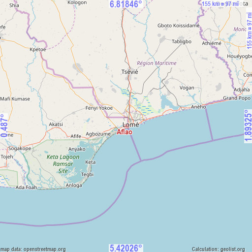
Aflao GPS coordinates[2]
6° 7' 11.352" North, 1° 11' 24.432" East
| Map corner | latitude | longitude |
|---|---|---|
| Upper-left | 6.81846°, | 0.487° |
| Center: | 6.11982°, | 1.19012° |
| Lower-right: | 5.42026°, | 1.89325° |
| Map W x H: | 155.5×155.5 km | = 96.6×96.6mi |
| max Lat: | 11.0616° ⇑48.6% North |
| Aflao: | 6.11982° |
| min Lat: | ⇓51.4% South 4.86641° |
| min Long | Aflao | max Long |
| -2.78516° | 1.19012° | 1.19012° |
| W 100%⇐ | ⇒0% E |
Elevation
Elevation of Aflao is 9 m = 30 ft, and this is 161.2 m = 529 ft below average elevation for this country.
| Max E: |
477 m = 1565 ft | 95.8% |
| Avg. | 170.2 m = 558 ft | |
| Aflao | 9 m = 30 ft | |
Min E: |
0 m = 0 ft | 4.2% |
See also: Aflao elevation on elevation.city.
Geographical zone
Aflao is located in North Torrid zone (between Equator and Tropic of Cancer). Distance of Equator is 680.5 km =422.8 mi to South.| Distance of | km | miles | from Aflao |
|---|---|---|---|
| North Pole | 9326.6 | 5795.3 | to North |
| Arctic Circle | 6720.7 | 4176 | to North |
| Tropic Cancer | 1925.5 | 1196.4 | to North |
| Equator | 680.5 | 422.8 | to South |


Nearby cities:
15 places around Aflao: (largest is in red/bold)
• Aburi
153.9 km =95.6 mi,  258°
258°
• Accra
165.7 km =103 mi,  247°
247°
• Akropong
142 km =88.2 mi, 263°
• Anloga
48.5 km =30.1 mi,  221°
221°
• Dome
166.2 km =103.3 mi, 251°
• Ho
95.8 km =59.5 mi,  303°
303°
• Hohoe
139.4 km =86.6 mi,  325°
325°
• Keta
31.7 km =19.7 mi, 224°
• Koforidua
160.3 km =99.6 mi,  268°
268°
• Kpandu
138.9 km =86.3 mi,  314°
314°
• Medina Estates
157.9 km =98.1 mi, 251°
• Nsawam
173.8 km =108 mi, 258°
• Nungua
151.6 km =94.2 mi, 247°
• Tema
142.5 km =88.5 mi, 249°
• Teshi Old Town
155.4 km =96.6 mi, 247°
Sources, notices
• [Note1] Compared only with cities in Ghana existing in our database
• [Src1] Map data: © OpenStreetMap contributors (CC-BY-SA)
• [Src2] Other city data from geonames.org with taken over terms of usage.
• [Src3] Geographical zone / Annual Mean Temperature by Robert A. Rohde @ Wikipedia
