Anloga geodata
Anloga (Volta) is a populated place; located in Ghana in Africa/Accra (GMT+0) time zone. With population of 29,748 people, there are 43 cities with bigger population in this country. Compared to other cities in Ghana, 65.3% of cities are located further ↑North; 97.2% of cities are located further ←West and 98.6% of cities have higher elevation than Anloga. Note1


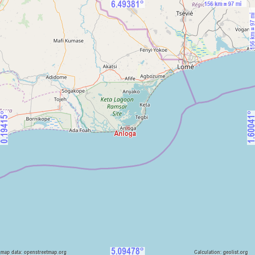
Anloga GPS coordinates[2]
5° 47' 41.028" North, 0° 53' 50.208" East
| Map corner | latitude | longitude |
|---|---|---|
| Upper-left | 6.49381°, | 0.19415° |
| Center: | 5.79473°, | 0.89728° |
| Lower-right: | 5.09478°, | 1.60041° |
| Map W x H: | 155.6×155.6 km | = 96.7×96.7mi |
| max Lat: | 11.0616° ⇑65.3% North |
| Anloga: | 5.79473° |
| min Lat: | ⇓34.7% South 4.86641° |
| min Long | Anloga | max Long |
| -2.78516° | 0.89728° | 1.19012° |
| W 97.2%⇐ | ⇒2.8% E |
Elevation
Elevation of Anloga is 6 m = 20 ft, and this is 164.2 m = 539 ft below average elevation for this country.
| Max E: |
477 m = 1565 ft | 98.6% |
| Avg. | 170.2 m = 558 ft | |
| Anloga | 6 m = 20 ft | |
Min E: |
0 m = 0 ft | 1.4% |
See also: Ghana elevation on elevation.city.
Geographical zone
Anloga is located in North Torrid zone (between Equator and Tropic of Cancer). Distance of Equator is 644.3 km =400.3 mi to South.| Distance of | km | miles | from Anloga |
|---|---|---|---|
| North Pole | 9362.7 | 5817.7 | to North |
| Arctic Circle | 6756.9 | 4198.5 | to North |
| Tropic Cancer | 1961.6 | 1218.9 | to North |
| Equator | 644.3 | 400.3 | to South |


Nearby cities:
15 places around Anloga: (largest is in red/bold)
• Aburi
118.7 km =73.8 mi,  272°
272°
• Accra
123.9 km =77 mi,  257°
257°
• Aflao
48.5 km =30.1 mi,  41°
41°
• Akropong
110.5 km =68.7 mi,  280°
280°
• Atsiaman
136 km =84.5 mi, 265°
• Dome
126.4 km =78.5 mi, 262°
• Gbawe
135.8 km =84.4 mi, 259°
• Ho
101.2 km =62.9 mi,  332°
332°
• Keta
17 km =10.6 mi, 36°
• Koforidua
132.1 km =82.1 mi, 284°
• Medina Estates
118.2 km =73.4 mi, 263°
• Nsawam
138 km =85.7 mi, 270°
• Nungua
109.9 km =68.3 mi, 258°
• Tema
102.1 km =63.4 mi, 262°
• Teshi Old Town
113.6 km =70.6 mi, 258°
Sources, notices
• [Note1] Compared only with cities in Ghana existing in our database
• [Src1] Map data: © OpenStreetMap contributors (CC-BY-SA)
• [Src2] Other city data from geonames.org with taken over terms of usage.
• [Src3] Geographical zone / Annual Mean Temperature by Robert A. Rohde @ Wikipedia
