Keta geodata
Keta (Volta) is a populated place; located in Ghana in Africa/Accra (GMT+0) time zone. With population of 18,077 people, there are 58 cities with bigger population in this country. Compared to other cities in Ghana, 58.3% of cities are located further ↑North; 98.6% of cities are located further ←West and 100% of cities have higher elevation than Keta. Note1


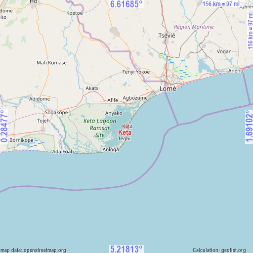
Keta GPS coordinates[2]
5° 55' 4.548" North, 0° 59' 16.404" East
| Map corner | latitude | longitude |
|---|---|---|
| Upper-left | 6.61685°, | 0.28477° |
| Center: | 5.91793°, | 0.98789° |
| Lower-right: | 5.21813°, | 1.69102° |
| Map W x H: | 155.5×155.5 km | = 96.6×96.6mi |
| max Lat: | 11.0616° ⇑58.3% North |
| Keta: | 5.91793° |
| min Lat: | ⇓41.7% South 4.86641° |
| min Long | Keta | max Long |
| -2.78516° | 0.98789° | 1.19012° |
| W 98.6%⇐ | ⇒1.4% E |
Elevation
Elevation of Keta is 0 m = 0 ft, and this is 170.2 m = 558 ft below average elevation for this country.
| Max E: |
477 m = 1565 ft | 100% |
| Avg. | 170.2 m = 558 ft | |
| Keta | 0 m = 0 ft | |
Min E: |
0 m = 0 ft | 0% |
See also: Ghana elevation on elevation.city.
Geographical zone
Keta is located in North Torrid zone (between Equator and Tropic of Cancer). Distance of Equator is 658 km =408.9 mi to South.| Distance of | km | miles | from Keta |
|---|---|---|---|
| North Pole | 9349 | 5809.2 | to North |
| Arctic Circle | 6743.2 | 4190 | to North |
| Tropic Cancer | 1947.9 | 1210.4 | to North |
| Equator | 658 | 408.9 | to South |


Nearby cities:
15 places around Keta: (largest is in red/bold)
• Aburi
128.8 km =80 mi,  266°
266°
• Accra
137.1 km =85.2 mi,  252°
252°
• Aflao
31.7 km =19.7 mi,  44°
44°
• Akropong
118.9 km =73.9 mi, 273°
• Anloga
17 km =10.6 mi,  216°
216°
• Atsiaman
147.6 km =91.7 mi,  260°
260°
• Dome
138.6 km =86.1 mi, 257°
• Gbawe
148.5 km =92.3 mi, 255°
• Ho
95 km =59 mi,  323°
323°
• Koforidua
139.3 km =86.6 mi,  278°
278°
• Kpandu
142.3 km =88.4 mi,  327°
327°
• Medina Estates
130.4 km =81 mi, 257°
• Nungua
123 km =76.4 mi, 253°
• Tema
114.5 km =71.1 mi, 256°
• Teshi Old Town
126.7 km =78.7 mi, 252°
Sources, notices
• [Note1] Compared only with cities in Ghana existing in our database
• [Src1] Map data: © OpenStreetMap contributors (CC-BY-SA)
• [Src2] Other city data from geonames.org with taken over terms of usage.
• [Src3] Geographical zone / Annual Mean Temperature by Robert A. Rohde @ Wikipedia
