Morales geodata
Morales (Izabal) is a seat of a second-order administrative division; located in Guatemala in America/Guatemala (GMT-6) time zone. With population of 18,994 people, there are 61 cities with bigger population in this country. Compared to other cities in Guatemala, 87% of cities are located further ↓South; 99.4% of cities are located further ←West and 97.6% of cities have higher elevation than Morales. Note1


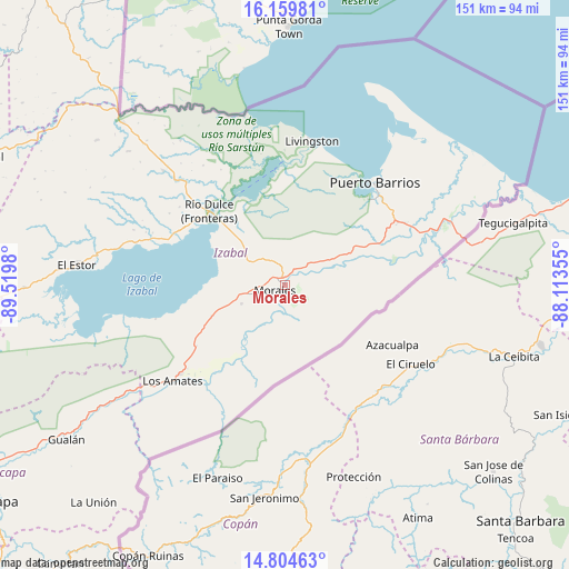
Morales GPS coordinates[2]
15° 28' 59.988" North, 88° 49' 0.012" West
| Map corner | latitude | longitude |
|---|---|---|
| Upper-left | 16.15981°, | -89.5198° |
| Center: | 15.48333°, | -88.81667° |
| Lower-right: | 14.80463°, | -88.11355° |
| Map W x H: | 150.7×150.7 km | = 93.6×93.6mi |
| max Lat: | 17.06606° ⇑13% North |
| Morales: | 15.48333° |
| min Lat: | ⇓87% South 13.9274° |
| min Long | Morales | max Long |
| -92.19298° | -88.81667° | -88.59444° |
| W 99.4%⇐ | ⇒0.59999999999999% E |
Elevation
Elevation of Morales is 37 m = 121 ft, and this is 1230 m = 4035 ft below average elevation for this country.
| Max E: |
3254 m = 10676 ft | 97.6% |
| Avg. | 1267 m = 4157 ft | |
| Morales | 37 m = 121 ft | |
Min E: |
1 m = 3 ft | 2.4% |
See also: Guatemala elevation on elevation.city.
Geographical zone
Morales is located in North Torrid zone (between Equator and Tropic of Cancer). Distance of this Northern Tropic circle is 884.3 km =549.5 mi to North.| Distance of | km | miles | from Morales |
|---|---|---|---|
| North Pole | 8285.5 | 5148.4 | to North |
| Arctic Circle | 5679.6 | 3529.1 | to North |
| Tropic Cancer | 884.3 | 549.5 | to North |
| Equator | 1721.6 | 1069.8 | to South |


Nearby cities:
15 places around Morales: (largest is in red/bold)
• Camotán
94.8 km =58.9 mi,  218°
218°
• Chahal Guatemala
91.1 km =56.6 mi,  292°
292°
• El Estor
57.4 km =35.7 mi,  275°
275°
• Estanzuela
96.8 km =60.1 mi,  236°
236°
• Gualán
70.7 km =43.9 mi, 235°
• Jocotán
96 km =59.7 mi, 219°
• La Unión
76.7 km =47.7 mi, 221°
• Los Amates
39.3 km =24.4 mi,  230°
230°
• Lívingston
39 km =24.2 mi,  10°
10°
• Panzós
91.6 km =56.9 mi,  264°
264°
• Puerto Barrios
36.1 km =22.4 mi,  41°
41°
• Río Hondo
94.4 km =58.7 mi, 240°
• San Jorge
102.5 km =63.7 mi, 233°
• San Juan Ermita
103.5 km =64.3 mi, 219°
• Zacapa
95.4 km =59.3 mi, 233°
Sources, notices
• [Note1] Compared only with cities in Guatemala existing in our database
• [Src1] Map data: © OpenStreetMap contributors (CC-BY-SA)
• [Src2] Other city data from geonames.org with taken over terms of usage.
• [Src3] Geographical zone / Annual Mean Temperature by Robert A. Rohde @ Wikipedia
