Puerto Barrios geodata
Puerto Barrios (Izabal) is a seat of a first-order administrative division; located in Guatemala in America/Guatemala (GMT-6) time zone. With population of 56,605 people, there are 16 cities with bigger population in this country. Compared to other cities in Guatemala, 92.3% of cities are located further ↓South; 100% of cities are located further ←West and 99.1% of cities have higher elevation than Puerto Barrios. Note1


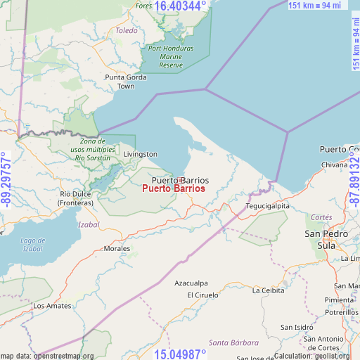
Puerto Barrios GPS coordinates[2]
15° 43' 40.008" North, 88° 35' 39.984" West
| Map corner | latitude | longitude |
|---|---|---|
| Upper-left | 16.40344°, | -89.29757° |
| Center: | 15.72778°, | -88.59444° |
| Lower-right: | 15.04987°, | -87.89132° |
| Map W x H: | 150.5×150.5 km | = 93.5×93.5mi |
| max Lat: | 17.06606° ⇑7.7% North |
| Puerto Barrios: | 15.72778° |
| min Lat: | ⇓92.3% South 13.9274° |
| min Long | Puerto Barrios | max Long |
| -92.19298° | -88.59444° | -88.59444° |
| W 100%⇐ | ⇒0% E |
Elevation
Elevation of Puerto Barrios is 7 m = 23 ft, and this is 1260 m = 4134 ft below average elevation for this country.
| Max E: |
3254 m = 10676 ft | 99.1% |
| Avg. | 1267 m = 4157 ft | |
| Puerto Barrios | 7 m = 23 ft | |
Min E: |
1 m = 3 ft | 0.9% |
See also: Puerto Barrios elevation on elevation.city.
Geographical zone
Puerto Barrios is located in North Torrid zone (between Equator and Tropic of Cancer). Distance of this Northern Tropic circle is 857.2 km =532.6 mi to North.| Distance of | km | miles | from Puerto Barrios |
|---|---|---|---|
| North Pole | 8258.3 | 5131.5 | to North |
| Arctic Circle | 5652.4 | 3512.2 | to North |
| Tropic Cancer | 857.2 | 532.6 | to North |
| Equator | 1748.8 | 1086.7 | to South |


Nearby cities:
15 places around Puerto Barrios: (largest is in red/bold)
• Camotán
130.9 km =81.3 mi,  219°
219°
• Chahal Guatemala
108.4 km =67.4 mi,  273°
273°
• Dolores
123.8 km =76.9 mi,  314°
314°
• El Estor
83.7 km =52 mi,  255°
255°
• Estanzuela
132 km =82 mi,  232°
232°
• Gualán
106.1 km =65.9 mi, 230°
• La Unión
112.8 km =70.1 mi, 221°
• Los Amates
75.2 km =46.7 mi, 225°
• Lívingston
20.1 km =12.5 mi,  303°
303°
• Morales
36.1 km =22.4 mi, 221°
• Panzós
120.5 km =74.9 mi,  252°
252°
• Poptún
110.6 km =68.7 mi, 307°
• Río Hondo
129 km =80.2 mi,  235°
235°
• San Luis
104.5 km =64.9 mi, 300°
• Zacapa
130.9 km =81.3 mi, 230°
Sources, notices
• [Note1] Compared only with cities in Guatemala existing in our database
• [Src1] Map data: © OpenStreetMap contributors (CC-BY-SA)
• [Src2] Other city data from geonames.org with taken over terms of usage.
• [Src3] Geographical zone / Annual Mean Temperature by Robert A. Rohde @ Wikipedia
