Császártöltés geodata
Császártöltés (Bács-Kiskun) is a populated place; located in Hungary in Europe/Budapest (GMT+2) time zone. With population of 2,649 people, there are 581 cities with bigger population in this country. Compared to other cities in Hungary, 88% of cities are located further ↑North; 57.2% of cities are located further →East and 61.1% of cities have higher elevation than Császártöltés. Note1


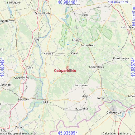
Császártöltés GPS coordinates[2]
46° 25' 18.984" North, 19° 11' 0.996" East
| Map corner | latitude | longitude |
|---|---|---|
| Upper-left | 46.90448°, | 18.48049° |
| Center: | 46.42194°, | 19.18361° |
| Lower-right: | 45.93509°, | 19.88674° |
| Map W x H: | 107.8×107.8 km | = 67×67mi |
| max Lat: | 48.46667° ⇑88% North |
| Császártöltés: | 46.42194° |
| min Lat: | ⇓12% South 45.79108° |
| min Long | Császártölt� | max Long |
| 16.27358° | 19.18361° | 22.68096° |
| W 42.8%⇐ | ⇒57.2% E |
Elevation
Elevation of Császártöltés is 109 m = 358 ft, and this is 20.7 m = 68 ft below average elevation for this country.
| Max E: |
444 m = 1457 ft | 61.1% |
| Avg. | 129.7 m = 426 ft | |
| Császártöltés | 109 m = 358 ft | |
Min E: |
71 m = 233 ft | 38.9% |
See also: Hungary elevation on elevation.city.
Geographical zone
Császártöltés is located in North temperate zone (between Tropic of Cancer and the Arctic Circle). Distance of this North polar circle is 2239.5 km =1391.6 mi to North.| Distance of | km | miles | from Császártöltés |
|---|---|---|---|
| North Pole | 4845.4 | 3010.8 | to North |
| Arctic Circle | 2239.5 | 1391.6 | to North |
| Tropic Cancer | 2555.7 | 1588 | to South |
| Equator | 5161.6 | 3207.3 | to South |


Nearby cities:
15 places around Császártöltés: (largest is in red/bold)
• Bátya
19 km =11.8 mi,  292°
292°
• Csávoly
26 km =16.2 mi,  186°
186°
• Dusnok
17.3 km =10.7 mi,  258°
258°
• Felsőszentiván
25 km =15.5 mi,  179°
179°
• Hajós
5.5 km =3.4 mi,  241°
241°
• Jánoshalma
17.5 km =10.9 mi,  141°
141°
• Kalocsa
20.1 km =12.5 mi,  306°
306°
• Kecel
12.6 km =7.8 mi,  24°
24°
• Kiskunhalas
23.1 km =14.4 mi,  86°
86°
• Kiskőrös
23.5 km =14.6 mi, 19°
• Kunfehértó
19 km =11.8 mi,  110°
110°
• Nemesnádudvar
13.6 km =8.5 mi,  228°
228°
• Soltvadkert
23.7 km =14.7 mi,  42°
42°
• Sükösd
21.3 km =13.2 mi,  222°
222°
• Érsekcsanád
24.2 km =15 mi, 219°
Sources, notices
• [Note1] Compared only with cities in Hungary existing in our database
• [Src1] Map data: © OpenStreetMap contributors (CC-BY-SA)
• [Src2] Other city data from geonames.org with taken over terms of usage.
• [Src3] Geographical zone / Annual Mean Temperature by Robert A. Rohde @ Wikipedia
