Kecel geodata
Kecel (Bács-Kiskun) is a populated place; located in Hungary in Europe/Budapest (GMT+2) time zone. With population of 9,155 people, there are 179 cities with bigger population in this country. Compared to other cities in Hungary, 85.7% of cities are located further ↑North; 55.7% of cities are located further →East and 69.7% of cities have higher elevation than Kecel. Note1


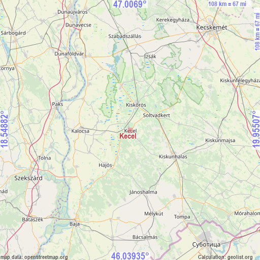
Kecel GPS coordinates[2]
46° 31' 31.008" North, 19° 15' 6.984" East
| Map corner | latitude | longitude |
|---|---|---|
| Upper-left | 47.0069°, | 18.54882° |
| Center: | 46.52528°, | 19.25194° |
| Lower-right: | 46.03935°, | 19.95507° |
| Map W x H: | 107.6×107.6 km | = 66.9×66.9mi |
| max Lat: | 48.46667° ⇑85.7% North |
| Kecel: | 46.52528° |
| min Lat: | ⇓14.3% South 45.79108° |
| min Long | Kecel | max Long |
| 16.27358° | 19.25194° | 22.68096° |
| W 44.3%⇐ | ⇒55.7% E |
Elevation
Elevation of Kecel is 102 m = 335 ft, and this is 27.7 m = 91 ft below average elevation for this country.
| Max E: |
444 m = 1457 ft | 69.7% |
| Avg. | 129.7 m = 426 ft | |
| Kecel | 102 m = 335 ft | |
Min E: |
71 m = 233 ft | 30.3% |
See also: Hungary elevation on elevation.city.
Geographical zone
Kecel is located in North temperate zone (between Tropic of Cancer and the Arctic Circle). Distance of this North polar circle is 2228 km =1384.4 mi to North.| Distance of | km | miles | from Kecel |
|---|---|---|---|
| North Pole | 4833.9 | 3003.6 | to North |
| Arctic Circle | 2228 | 1384.4 | to North |
| Tropic Cancer | 2567.2 | 1595.2 | to South |
| Equator | 5173.1 | 3214.4 | to South |


Nearby cities:
15 places around Kecel: (largest is in red/bold)
• Akasztó
18.9 km =11.7 mi,  348°
348°
• Bátya
23.2 km =14.4 mi,  259°
259°
• Csengőd
21.2 km =13.2 mi,  3°
3°
• Császártöltés
12.6 km =7.8 mi,  204°
204°
• Dunapataj
23.6 km =14.7 mi,  304°
304°
• Hajós
17.3 km =10.7 mi,  215°
215°
• Harta
25.5 km =15.8 mi,  318°
318°
• Jánoshalma
25.8 km =16 mi,  167°
167°
• Kalocsa
21.4 km =13.3 mi,  271°
271°
• Kiskunhalas
20.5 km =12.7 mi,  119°
119°
• Kiskőrös
11 km =6.8 mi,  13°
13°
• Kunfehértó
22.1 km =13.7 mi,  145°
145°
• Nemesnádudvar
25.7 km =16 mi, 216°
• Soltvadkert
12.4 km =7.7 mi,  61°
61°
• Tázlár
20.2 km =12.6 mi,  82°
82°
Sources, notices
• [Note1] Compared only with cities in Hungary existing in our database
• [Src1] Map data: © OpenStreetMap contributors (CC-BY-SA)
• [Src2] Other city data from geonames.org with taken over terms of usage.
• [Src3] Geographical zone / Annual Mean Temperature by Robert A. Rohde @ Wikipedia
