Kunfehértó geodata
Kunfehértó (Bács-Kiskun) is a populated place; located in Hungary in Europe/Budapest (GMT+2) time zone. With population of 2,281 people, there are 680 cities with bigger population in this country. Compared to other cities in Hungary, 90.3% of cities are located further ↑North; 51.8% of cities are located further →East and 67.7% of cities have lower elevation than Kunfehértó. Note1


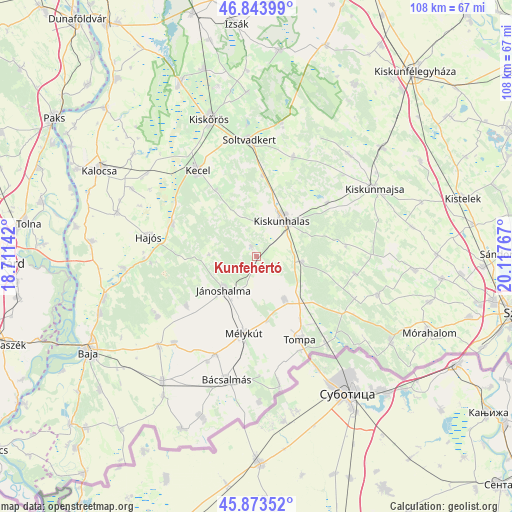
Kunfehértó GPS coordinates[2]
46° 21' 39.276" North, 19° 24' 52.344" East
| Map corner | latitude | longitude |
|---|---|---|
| Upper-left | 46.84399°, | 18.71142° |
| Center: | 46.36091°, | 19.41454° |
| Lower-right: | 45.87352°, | 20.11767° |
| Map W x H: | 107.9×107.9 km | = 67×67mi |
| max Lat: | 48.46667° ⇑90.3% North |
| Kunfehértó: | 46.36091° |
| min Lat: | ⇓9.7% South 45.79108° |
| min Long | Kunfehértó | max Long |
| 16.27358° | 19.41454° | 22.68096° |
| W 48.2%⇐ | ⇒51.8% E |
Elevation
Elevation of Kunfehértó is 134 m = 440 ft, and this is 4.3 m = 14 ft above average elevation for this country.
| Max E: |
444 m = 1457 ft | 32.3% |
| Kunfehértó | 134 m 440 ft | |
| Avg. | 129.7 m = 426 ft | |
Min E: |
71 m = 233 ft | 67.7% |
See also: Hungary elevation on elevation.city.
Geographical zone
Kunfehértó is located in North temperate zone (between Tropic of Cancer and the Arctic Circle). Distance of this North polar circle is 2246.3 km =1395.8 mi to North.| Distance of | km | miles | from Kunfehértó |
|---|---|---|---|
| North Pole | 4852.2 | 3015 | to North |
| Arctic Circle | 2246.3 | 1395.8 | to North |
| Tropic Cancer | 2548.9 | 1583.8 | to South |
| Equator | 5154.8 | 3203 | to South |


Nearby cities:
15 places around Kunfehértó: (largest is in red/bold)
• Bácsalmás
26.8 km =16.7 mi,  193°
193°
• Császártöltés
19 km =11.8 mi,  290°
290°
• Felsőszentiván
25.3 km =15.7 mi,  223°
223°
• Hajós
22.9 km =14.2 mi,  280°
280°
• Jánoshalma
9.7 km =6 mi, 224°
• Kecel
22.1 km =13.7 mi,  325°
325°
• Kelebia
24 km =14.9 mi,  139°
139°
• Kiskunhalas
9.8 km =6.1 mi,  33°
33°
• Kisszállás
10.7 km =6.6 mi,  147°
147°
• Mélykút
16.4 km =10.2 mi, 189°
• Nemesnádudvar
28 km =17.4 mi,  265°
265°
• Ruzsa
26.8 km =16.7 mi,  107°
107°
• Soltvadkert
24.3 km =15.1 mi,  356°
356°
• Tompa
19.7 km =12.2 mi, 150°
• Tázlár
22.2 km =13.8 mi,  20°
20°
Sources, notices
• [Note1] Compared only with cities in Hungary existing in our database
• [Src1] Map data: © OpenStreetMap contributors (CC-BY-SA)
• [Src2] Other city data from geonames.org with taken over terms of usage.
• [Src3] Geographical zone / Annual Mean Temperature by Robert A. Rohde @ Wikipedia
