Sampit geodata
Sampit (Central Kalimantan) is a seat of a second-order administrative division; located in Indonesia in Asia/Pontianak (GMT+7) time zone. With population of 66,053 people, there are 186 cities with bigger population in this country. Compared to other cities in Indonesia, 92.2% of cities are located further ↓South; 58.7% of cities are located further ←West and 98.5% of cities have higher elevation than Sampit. Note1


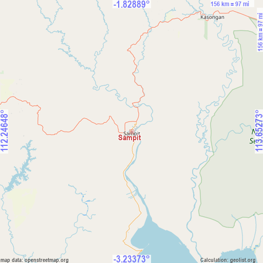
Sampit GPS coordinates[2]
2° 31' 53.4" South, 112° 56' 58.56" East
| Map corner | latitude | longitude |
|---|---|---|
| Upper-left | -1.82889°, | 112.24648° |
| Center: | -2.5315°, | 112.9496° |
| Lower-right: | -3.23373°, | 113.65273° |
| Map W x H: | 156.2×156.2 km | = 97.1×97.1mi |
| max Lat: | 5.88969° ⇑7.8% North |
| Sampit: | -2.5315° |
| min Lat: | ⇓92.2% South -10.934° |
| min Long | Sampit | max Long |
| 95.1345° | 112.9496° | 140.9419° |
| W 58.7%⇐ | ⇒41.3% E |
Elevation
Elevation of Sampit is 5 m = 16 ft, and this is 224.7 m = 737 ft below average elevation for this country.
| Max E: |
3185 m = 10449 ft | 98.5% |
| Avg. | 229.7 m = 754 ft | |
| Sampit | 5 m = 16 ft | |
Min E: |
-1 m = -3 ft | 1.5% |
See also: Sampit elevation on elevation.city.
Geographical zone
Sampit is located in South Torrid zone (between Equator and Tropic of Capricorn). Distance of Equator is 281.5 km =174.9 mi to North.| Distance of | km | miles | from Sampit |
|---|---|---|---|
| Equator | 281.5 | 174.9 | to North |
| Tropic Capricorn | 2324.4 | 1444.3 | to South |
| Antarctic Circle | 7119.7 | 4424 | to South |
| South Pole | 9725.6 | 6043.2 | to South |


Nearby cities:
15 places around Sampit: (largest is in red/bold)
• Basarang
157.4 km =97.8 mi,  107°
107°
• Halimaung Jaya (F-3)
91.7 km =57 mi,  209°
209°
• Kotabesi
18.7 km =11.6 mi,  18°
18°
• Kuala Pembuang
105.5 km =65.6 mi,  204°
204°
• Kumai
137.9 km =85.7 mi,  260°
260°
• Pagatan
80.3 km =49.9 mi,  152°
152°
• Palangkaraya
113.3 km =70.4 mi,  71°
71°
• Pangkalanbuun
148 km =92 mi, 263°
• Pembuanghulu
88.7 km =55.1 mi,  271°
271°
• Petakbehandang
74 km =46 mi,  46°
46°
• Pulang Pisau
145.8 km =90.6 mi,  100°
100°
• Rantaupulut
101.9 km =63.3 mi,  304°
304°
• Semilat
85.7 km =53.3 mi,  286°
286°
• Semuda
36.8 km =22.9 mi,  175°
175°
• Tongkiling
111.9 km =69.5 mi, 66°
Sources, notices
• [Note1] Compared only with cities in Indonesia existing in our database
• [Src1] Map data: © OpenStreetMap contributors (CC-BY-SA)
• [Src2] Other city data from geonames.org with taken over terms of usage.
• [Src3] Geographical zone / Annual Mean Temperature by Robert A. Rohde @ Wikipedia
