Kumai geodata
Kumai (Central Kalimantan) is a seat of a third-order administrative division; located in Indonesia in Asia/Pontianak (GMT+7) time zone. In our database, there are 407 cities with bigger population. Compared to other cities in Indonesia, 91.7% of cities are located further ↓South; 53.9% of cities are located further →East and 98.5% of cities have higher elevation than Kumai. Note1


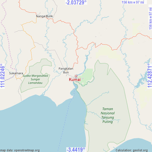
Kumai GPS coordinates[2]
2° 44' 23.28" South, 111° 43' 32.088" East
| Map corner | latitude | longitude |
|---|---|---|
| Upper-left | -2.03729°, | 111.02246° |
| Center: | -2.7398°, | 111.72558° |
| Lower-right: | -3.4419°, | 112.42871° |
| Map W x H: | 156.2×156.2 km | = 97.1×97.1mi |
| max Lat: | 5.88969° ⇑8.3% North |
| Kumai: | -2.7398° |
| min Lat: | ⇓91.7% South -10.934° |
| min Long | Kumai | max Long |
| 95.1345° | 111.72558° | 140.9419° |
| W 46.1%⇐ | ⇒53.9% E |
Elevation
Elevation of Kumai is 5 m = 16 ft, and this is 224.7 m = 737 ft below average elevation for this country.
| Max E: |
3185 m = 10449 ft | 98.5% |
| Avg. | 229.7 m = 754 ft | |
| Kumai | 5 m = 16 ft | |
Min E: |
-1 m = -3 ft | 1.5% |
See also: Indonesia elevation on elevation.city.
Geographical zone
Kumai is located in South Torrid zone (between Equator and Tropic of Capricorn). Distance of Equator is 304.6 km =189.3 mi to North.| Distance of | km | miles | from Kumai |
|---|---|---|---|
| Equator | 304.6 | 189.3 | to North |
| Tropic Capricorn | 2301.3 | 1430 | to South |
| Antarctic Circle | 7096.5 | 4409.6 | to South |
| South Pole | 9702.4 | 6028.8 | to South |


Nearby cities:
15 places around Kumai: (largest is in red/bold)
• Halimaung Jaya (F-3)
107.1 km =66.5 mi,  121°
121°
• Ketapang
218.6 km =135.8 mi,  297°
297°
• Kotabesi
147.6 km =91.7 mi,  73°
73°
• Kotawaringin
40.8 km =25.4 mi,  316°
316°
• Kuala Pembuang
116.8 km =72.6 mi,  128°
128°
• Manismata
82.7 km =51.4 mi,  291°
291°
• Nanga Bulik
69.4 km =43.1 mi,  337°
337°
• Pagatan
180 km =111.8 mi,  105°
105°
• Pangkalanbuun
12.7 km =7.9 mi, 299°
• Pembuanghulu
53.8 km =33.4 mi,  61°
61°
• Petakbehandang
203.8 km =126.6 mi, 68°
• Rantaupulut
96.6 km =60 mi,  32°
32°
• Sampit
137.9 km =85.7 mi,  80°
80°
• Semilat
72.3 km =44.9 mi,  48°
48°
• Semuda
139.2 km =86.5 mi,  95°
95°
Sources, notices
• [Note1] Compared only with cities in Indonesia existing in our database
• [Src1] Map data: © OpenStreetMap contributors (CC-BY-SA)
• [Src2] Other city data from geonames.org with taken over terms of usage.
• [Src3] Geographical zone / Annual Mean Temperature by Robert A. Rohde @ Wikipedia
