Pangkalanbuun geodata
Pangkalanbuun (Central Kalimantan) is a populated place; located in Indonesia in Asia/Pontianak (GMT+7) time zone. With population of 38,057 people, there are 278 cities with bigger population in this country. Compared to other cities in Indonesia, 91.9% of cities are located further ↓South; 55.8% of cities are located further →East and 83% of cities have higher elevation than Pangkalanbuun. Note1


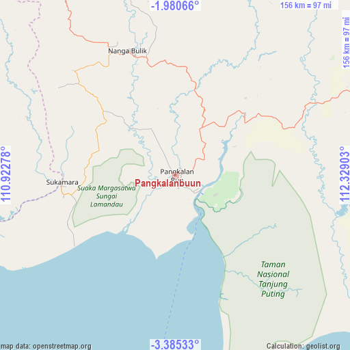
Pangkalanbuun GPS coordinates[2]
2° 40' 59.52" South, 111° 37' 33.24" East
| Map corner | latitude | longitude |
|---|---|---|
| Upper-left | -1.98066°, | 110.92278° |
| Center: | -2.6832°, | 111.6259° |
| Lower-right: | -3.38533°, | 112.32903° |
| Map W x H: | 156.2×156.2 km | = 97.1×97.1mi |
| max Lat: | 5.88969° ⇑8.1% North |
| Pangkalanbuun: | -2.6832° |
| min Lat: | ⇓91.9% South -10.934° |
| min Long | Pangkalanbuun | max Long |
| 95.1345° | 111.6259° | 140.9419° |
| W 44.2%⇐ | ⇒55.8% E |
Elevation
Elevation of Pangkalanbuun is 16 m = 52 ft, and this is 213.7 m = 701 ft below average elevation for this country.
| Max E: |
3185 m = 10449 ft | 83% |
| Avg. | 229.7 m = 754 ft | |
| Pangkalanbuun | 16 m = 52 ft | |
Min E: |
-1 m = -3 ft | 17% |
See also: Indonesia elevation on elevation.city.
Geographical zone
Pangkalanbuun is located in South Torrid zone (between Equator and Tropic of Capricorn). Distance of Equator is 298.3 km =185.4 mi to North.| Distance of | km | miles | from Pangkalanbuun |
|---|---|---|---|
| Equator | 298.3 | 185.4 | to North |
| Tropic Capricorn | 2307.6 | 1433.9 | to South |
| Antarctic Circle | 7102.8 | 4413.5 | to South |
| South Pole | 9708.7 | 6032.7 | to South |


Nearby cities:
15 places around Pangkalanbuun: (largest is in red/bold)
• Halimaung Jaya (F-3)
119.9 km =74.5 mi,  121°
121°
• Ketapang
205.8 km =127.9 mi,  297°
297°
• Kotabesi
156.8 km =97.4 mi,  77°
77°
• Kotawaringin
28.9 km =18 mi,  324°
324°
• Kuala Pembuang
129.4 km =80.4 mi,  127°
127°
• Kumai
12.7 km =7.9 mi, 119°
• Manismata
70.1 km =43.6 mi,  290°
290°
• Nanga Bulik
59.9 km =37.2 mi,  345°
345°
• Pagatan
192.4 km =119.6 mi,  106°
106°
• Pembuanghulu
61.5 km =38.2 mi,  71°
71°
• Petakbehandang
212.1 km =131.8 mi, 71°
• Rantaupulut
98.1 km =61 mi,  40°
40°
• Sampit
148 km =92 mi, 83°
• Semilat
77.3 km =48 mi,  57°
57°
• Semuda
150.9 km =93.8 mi,  97°
97°
Sources, notices
• [Note1] Compared only with cities in Indonesia existing in our database
• [Src1] Map data: © OpenStreetMap contributors (CC-BY-SA)
• [Src2] Other city data from geonames.org with taken over terms of usage.
• [Src3] Geographical zone / Annual Mean Temperature by Robert A. Rohde @ Wikipedia
