Kotabesi geodata
Kotabesi (Central Kalimantan) is a seat of a third-order administrative division; located in Indonesia in Asia/Pontianak (GMT+7) time zone. In our database, there are 407 cities with bigger population. Compared to other cities in Indonesia, 92.4% of cities are located further ↓South; 58.9% of cities are located further ←West and 90.6% of cities have higher elevation than Kotabesi. Note1


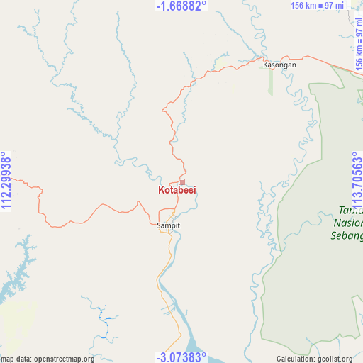
Kotabesi GPS coordinates[2]
2° 22' 17.4" South, 113° 0' 9" East
| Map corner | latitude | longitude |
|---|---|---|
| Upper-left | -1.66882°, | 112.29938° |
| Center: | -2.3715°, | 113.0025° |
| Lower-right: | -3.07383°, | 113.70563° |
| Map W x H: | 156.2×156.2 km | = 97.1×97.1mi |
| max Lat: | 5.88969° ⇑7.6% North |
| Kotabesi: | -2.3715° |
| min Lat: | ⇓92.4% South -10.934° |
| min Long | Kotabesi | max Long |
| 95.1345° | 113.0025° | 140.9419° |
| W 58.9%⇐ | ⇒41.1% E |
Elevation
Elevation of Kotabesi is 10 m = 33 ft, and this is 219.7 m = 721 ft below average elevation for this country.
| Max E: |
3185 m = 10449 ft | 90.6% |
| Avg. | 229.7 m = 754 ft | |
| Kotabesi | 10 m = 33 ft | |
Min E: |
-1 m = -3 ft | 9.4% |
See also: Indonesia elevation on elevation.city.
Geographical zone
Kotabesi is located in South Torrid zone (between Equator and Tropic of Capricorn). Distance of Equator is 263.7 km =163.9 mi to North.| Distance of | km | miles | from Kotabesi |
|---|---|---|---|
| Equator | 263.7 | 163.9 | to North |
| Tropic Capricorn | 2342.2 | 1455.4 | to South |
| Antarctic Circle | 7137.5 | 4435 | to South |
| South Pole | 9743.4 | 6054.3 | to South |


Nearby cities:
15 places around Kotabesi: (largest is in red/bold)
• Halimaung Jaya (F-3)
110.1 km =68.4 mi,  207°
207°
• Kuala Pembuang
124.1 km =77.1 mi,  203°
203°
• Kumai
147.6 km =91.7 mi,  253°
253°
• Matangai
154 km =95.7 mi,  98°
98°
• Pagatan
94.3 km =58.6 mi,  160°
160°
• Palangkaraya
103.2 km =64.1 mi,  79°
79°
• Pangkalanbuun
156.8 km =97.4 mi,  257°
257°
• Pembuanghulu
95.8 km =59.5 mi, 260°
• Petakbehandang
58.2 km =36.2 mi,  55°
55°
• Pulang Pisau
144.4 km =89.7 mi,  107°
107°
• Rantaupulut
98.3 km =61.1 mi,  294°
294°
• Sampit
18.7 km =11.6 mi, 198°
• Semilat
88.1 km =54.7 mi,  274°
274°
• Semuda
54.6 km =33.9 mi,  183°
183°
• Tongkiling
100.5 km =62.4 mi,  74°
74°
Sources, notices
• [Note1] Compared only with cities in Indonesia existing in our database
• [Src1] Map data: © OpenStreetMap contributors (CC-BY-SA)
• [Src2] Other city data from geonames.org with taken over terms of usage.
• [Src3] Geographical zone / Annual Mean Temperature by Robert A. Rohde @ Wikipedia
