Manismata geodata
Manismata (West Kalimantan) is a populated place; located in Indonesia in Asia/Pontianak (GMT+7) time zone. With population of 18,888 people, there are 371 cities with bigger population in this country. Compared to other cities in Indonesia, 92.3% of cities are located further ↓South; 64.5% of cities are located further →East and 71.9% of cities have higher elevation than Manismata. Note1


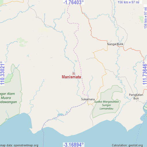
Manismata GPS coordinates[2]
2° 28' 0.012" South, 111° 1' 59.988" East
| Map corner | latitude | longitude |
|---|---|---|
| Upper-left | -1.76403°, | 110.33021° |
| Center: | -2.46667°, | 111.03333° |
| Lower-right: | -3.16894°, | 111.73646° |
| Map W x H: | 156.2×156.2 km | = 97.1×97.1mi |
| max Lat: | 5.88969° ⇑7.7% North |
| Manismata: | -2.46667° |
| min Lat: | ⇓92.3% South -10.934° |
| min Long | Manismata | max Long |
| 95.1345° | 111.03333° | 140.9419° |
| W 35.5%⇐ | ⇒64.5% E |
Elevation
Elevation of Manismata is 29 m = 95 ft, and this is 200.7 m = 658 ft below average elevation for this country.
| Max E: |
3185 m = 10449 ft | 71.9% |
| Avg. | 229.7 m = 754 ft | |
| Manismata | 29 m = 95 ft | |
Min E: |
-1 m = -3 ft | 28.1% |
See also: Indonesia elevation on elevation.city.
Geographical zone
Manismata is located in South Torrid zone (between Equator and Tropic of Capricorn). Distance of Equator is 274.3 km =170.4 mi to North.| Distance of | km | miles | from Manismata |
|---|---|---|---|
| Equator | 274.3 | 170.4 | to North |
| Tropic Capricorn | 2331.7 | 1448.9 | to South |
| Antarctic Circle | 7126.9 | 4428.4 | to South |
| South Pole | 9732.8 | 6047.7 | to South |


Nearby cities:
15 places around Manismata: (largest is in red/bold)
• Halimaung Jaya (F-3)
189 km =117.4 mi,  117°
117°
• Kenyau
184.4 km =114.6 mi,  341°
341°
• Ketapang
136.5 km =84.8 mi,  300°
300°
• Kotabesi
219 km =136.1 mi,  87°
87°
• Kotawaringin
48.9 km =30.4 mi, 90°
• Kuala Pembuang
197.4 km =122.7 mi, 121°
• Kumai
82.7 km =51.4 mi,  111°
111°
• Nanga Bulik
60.8 km =37.8 mi,  56°
56°
• Pangkalanbuun
70.1 km =43.6 mi, 110°
• Pembuanghulu
124.3 km =77.2 mi, 92°
• Rantaupulut
138.8 km =86.2 mi,  68°
68°
• Sampit
213 km =132.4 mi, 91°
• Semilat
132.1 km =82.1 mi,  82°
82°
• Semuda
219.9 km =136.6 mi,  101°
101°
• Sukadana
181.1 km =112.5 mi,  318°
318°
Sources, notices
• [Note1] Compared only with cities in Indonesia existing in our database
• [Src1] Map data: © OpenStreetMap contributors (CC-BY-SA)
• [Src2] Other city data from geonames.org with taken over terms of usage.
• [Src3] Geographical zone / Annual Mean Temperature by Robert A. Rohde @ Wikipedia
